2000-2009 Maps of Whatcom County, Washington
Explore 9 historic maps of Whatcom County from 2000-2009. These maps offer a rare glimpse into what life looked like during the 2000s — showing old roads, neighborhoods, homes, and landmarks that have changed or disappeared over time.
Whether you're researching your family's past, planning a metal detecting trip, or studying how Whatcom County's landscape evolved across the 2000s, these high-resolution maps are a powerful tool for exploring the history of this region.
- Focus on a specific era: All maps on this page are from the 2000s, giving you a focused view of this time period.
- See what’s changed: Compare century-old streets, trails, and buildings to today's modern landscape using overlays and satellite layers.
- Research with precision: Use these maps for genealogy, historical research, land use analysis, or educational projects.
- View, download, or print: Maps are fully viewable online in high resolution, and can be downloaded or printed for your own records.
Start exploring Whatcom County's history through authentic maps from the 2000s. This is your window into the past.
Whatcom County, WA maps
(9)- 2002 Map of Slate Peak, 2006 Print
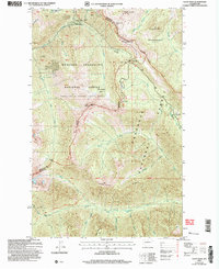 2002 Slate Peak2006 Print · USGSOkanogan County's high-altitude wilderness and mining legacy are preserved here as they stood in the early 2000s. Trace the path of the Pacific Crest National Scenic Trail past historic sites like the Illinois Mine and Harts Pass Guard Station.
 - 2002 Map of Azurite Peak, 2006 Print
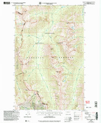
 2002 Azurite Peak2006 Print · USGSThe high Cascades of Whatcom and Skagit counties are shown here as a wilderness of deep canyons and mineral prospects at the start of the 2000s. Researchers can locate remote sites like the Azurite Mine, Fourmile Camp, and the high crossing at Cady Pass.
 - 2002 Map of Pasayten Peak, 2006 Print
 2002 Pasayten Peak2006 Print · USGSThe high Cascades at the turn of the millennium are captured here, centered on the remote wilderness where Okanogan and Whatcom counties meet. Researchers can trace the historic mining site at Barron or locate old Mines and Prospects near Windy Pass and Foggy Pass.
 - 2002 Map of Hozomeen Mountain, 2006 Print
 2002 Hozomeen Mountain2006 Print · USGSThe northern reaches of the Skagit River at the turn of the millennium are shown in high detail where the Washington border meets Canada. Researchers can locate remote outposts and high-altitude landmarks like Desolation Lookout, the Hozomeen Ranger Station, and Stromberg Cabin.
 - 2002 Map of Skagit Peak, 2006 Print
 2002 Skagit Peak2006 Print · USGSThe Washington-British Columbia borderlands are captured here in the early 2000s, showing a high alpine landscape defined by the Pasayten Wilderness. Local historians and hikers can trace remote landmarks like Deer Lick Cabin, Nightmare Camp, and the Little Fish Trail.
 - 2002 Map of Shull Mountain, 2006 Print
 2002 Shull Mountain2006 Print · USGSHigh in the North Cascades at the turn of the millennium, this survey details the intersection of the Pasayten Wilderness and Mt Baker - Snoqualmie National Forest. Trace the path of the Pacific Crest National Scenic Trail past landmarks like the Devils Park Shelter and Shull Lake.
 - 2002 Map of Pumpkin Mountain, 2006 Print
 2002 Pumpkin Mountain2006 Print · USGSThe North Cascades backcountry is mapped here in the early 2000s, detailing the transition from national park wilderness to recreation areas. You can locate remote stock and boat camps like Big Beaver (Stock Camp), Lodgepole, and Devils Creek (Boat Camp).
 - 2002 Map of Jack Mountain, 2006 Print
 2002 Jack Mountain2006 Print · USGSThe North Cascades high country comes into focus in the early 2000s, showing the intersection of wilderness and recreation areas. Trace the limits of the Nohokomeen Glacier or locate the remote Bear Skull Shelter and the alpine Jerry Lakes.
 - 2002 Map of Castle Peak, 2006 Print
 2002 Castle Peak2006 Print · USGSThe North Cascades backcountry at the turn of the century shows a landscape preserved for recreation and wilderness. Trace the iconic Pacific Crest National Scenic Trail past landmarks like Devils Stairway, Hopkins Lake, and Mountain Home Camp.
End of results
Showing maps 1-9 of 9
Top cities of Whatcom County
- Bellingham historical maps
- Lynden historical maps
- Ferndale historical maps
- Point Roberts historical maps
- Maple Falls historical maps
- Glacier historical maps
Frequently asked questions
- What are the different types of historical maps available for Whatcom County?
- What is the oldest map of Whatcom County?
- Where can I purchase historical maps of Whatcom County for my home or office?
- Where can I download high-res historical maps of Whatcom County?
- Are there historical topographic maps available for Whatcom County?
- Is there historical aerial imagery available for Whatcom County?
- Where are historical maps of Whatcom County sourced from?