1930s Maps of Yakima County, Washington
Explore 4 historic maps of Yakima County from the 1930s. These maps offer a rare glimpse into what life looked like during the 1930s — showing old roads, neighborhoods, homes, and landmarks that have changed or disappeared over time.
Whether you're researching your family's past, planning a metal detecting trip, or studying how Yakima County's landscape evolved across the 1930s, these high-resolution maps are a powerful tool for exploring the history of this region.
- Focus on a specific era: All maps on this page are from the 1930s, giving you a focused view of this time period.
- See what’s changed: Compare century-old streets, trails, and buildings to today's modern landscape using overlays and satellite layers.
- Research with precision: Use these maps for genealogy, historical research, land use analysis, or educational projects.
- View, download, or print: Maps are fully viewable online in high resolution, and can be downloaded or printed for your own records.
Start exploring Yakima County's history through authentic maps from the 1930s. This is your window into the past.
Yakima County, WA maps
(4)- 1931 Map of Steamboat Mtn
 1931 Steamboat Mtn1931 Print · USGSSkamania and Lewis Counties appear as a managed wilderness of national forests in the years before World War II. Researchers can trace the early footprint of forest management at the Cispus Lookout Sta and remote sites like Graveyard Camp or Buckhorn Camp.2 unique versions available
 - 1936 Map of Yakima East
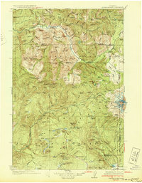
 1936 Yakima East1936 Print · USGSYakima and the Moxee Valley are shown here in the mid-1930s as the regional irrigation and rail networks were fully established. Genealogists and local historians can trace family locations near Pease Ranch, Moxee City, and schools like Central Sch.
 - 1936 Map of Hog Ranch Buttes
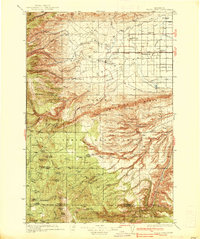
 1936 Hog Ranch Buttes1936 Print · USGSYakima and Kittitas counties are captured here in the mid-thirties, showing a vast ranching landscape defined by high ridges and deep canyons. Family historians can trace homesteads like Holmes Ranch and Meeboer Ranch, or locate local landmarks like Taylor Sch.
 - 1937 Map of White Swan
 1937 White Swan1937 Print · USGSThe Yakima Indian Reservation in the mid-1930s reveals a landscape of high ridges meeting an emerging irrigation frontier. Genealogists and historians can trace early school sites like Medicine Valley Sch, the rail-stop at Harrah, and the historic grounds of Fort Simcoe.3 unique versions available
End of results
Showing maps 1-4 of 4
Top cities of Yakima County
- Yakima historical maps
- Sunnyside historical maps
- Grandview historical maps
- Toppenish historical maps
- Selah historical maps
- Union Gap historical maps
See more
Frequently asked questions
- What are the different types of historical maps available for Yakima County?
- What is the oldest map of Yakima County?
- Where can I purchase historical maps of Yakima County for my home or office?
- Where can I download high-res historical maps of Yakima County?
- Are there historical topographic maps available for Yakima County?
- Is there historical aerial imagery available for Yakima County?
- Where are historical maps of Yakima County sourced from?