1990s Maps of Yakima County, Washington
Explore 15 historic maps of Yakima County from the 1990s. These maps offer a rare glimpse into what life looked like during the 1990s — showing old roads, neighborhoods, homes, and landmarks that have changed or disappeared over time.
Whether you're researching your family's past, planning a metal detecting trip, or studying how Yakima County's landscape evolved across the 1990s, these high-resolution maps are a powerful tool for exploring the history of this region.
- Focus on a specific era: All maps on this page are from the 1990s, giving you a focused view of this time period.
- See what’s changed: Compare century-old streets, trails, and buildings to today's modern landscape using overlays and satellite layers.
- Research with precision: Use these maps for genealogy, historical research, land use analysis, or educational projects.
- View, download, or print: Maps are fully viewable online in high resolution, and can be downloaded or printed for your own records.
Start exploring Yakima County's history through authentic maps from the 1990s. This is your window into the past.
Yakima County, WA maps
(15)- 1992 Map of Cliffdell, 1996 Print
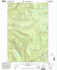
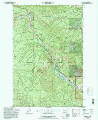 1992 Cliffdell1996 Print · USGSThe Naches River valley in the early nineties highlights a landscape of forest management and mountain recreation. Researchers can trace local landmarks like Peterson Cem and Camp Roganunda, or locate natural features such as Boulder Cave and Milk Pond.
 - 1992 Map of Meeks Table, 1996 Print
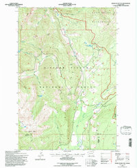
 1992 Meeks Table1996 Print · USGSThe high country of Yakima County in the early nineties is a landscape of protected wilderness and rugged forest administration. Trace the high-altitude hydrology and geography of the Cascades through remote features like McDaniel Lake, Cowpuncher Ridge, and the Meeks Table Natural Area.
 - 1992 Map of Manastash Lake, 1996 Print
 1992 Manastash Lake1996 Print · USGSThe high Cascades at the Kittitas and Yakima county line appear here in the early 1990s, centered on the historic Naches Pass Trail. Researchers can trace old mountain routes through Canteen Flats and locate remote water sources like Manastash Lake and Cattle Camp Spring.
 - 1992 Map of Rimrock Lake, 1996 Print
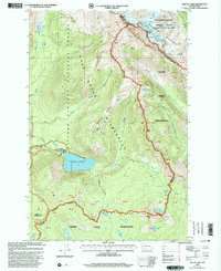
 1992 Rimrock Lake1996 Print · USGSThe Yakima County backcountry in the early nineties shows a landscape of deep wilderness and federal forest management. Researchers can trace the drainages of Rimrock Lake and find remote landmarks like Ironstone Mtn or the high Strawberry Meadows.
 - 1992 Map of Old Scab Mtn, 1996 Print
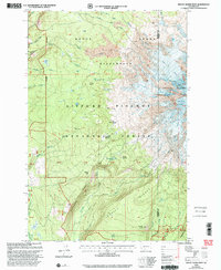
 1992 Old Scab Mtn1996 Print · USGSThe high Cascades of Yakima County are documented here in the early nineties, centered on the protected reaches of the William O Douglas Wilderness. Hikers and historians can trace old routes near American Forks, Saddle Camp, and the Soda Springs Footbridge.
 - 1992 Map of Tieton Basin, 1996 Print
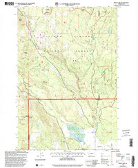
 1992 Tieton Basin1996 Print · USGSThe Tieton River valley and surrounding National Forest ridges are documented here in the early 1990s. Researchers can locate Rimrock, trace the Tieton River, and identify landmarks like Kloochman Rock and Jumpoff Meadows.
 - 1994 Map of Hamilton Buttes, 1996 Print
 1994 Hamilton Buttes1996 Print · USGSThe Cascades high country of Lewis County comes to life in the mid-nineties, showing a landscape defined by protected wilderness and timber management. Hikers and researchers can locate landmarks like Sanctuary Arch and St Michael Lake, or trace the rugged Goat Ridge.
 - 1994 Map of Green Mountain, 1996 Print
 1994 Green Mountain1996 Print · USGSThe High Cascades in the mid-nineties come into focus here, showing the intersection of forest service lands and tribal boundaries. Trace the high-altitude Pacific Crest National Scenic Trail past Takhlakh Lake and the LAVA fields.
 - 1998 Map of Glaciate Butte, 2003 Print
 1998 Glaciate Butte2003 Print · USGSThe Yakama Indian Reservation and Gifford Pinchot National Forest meet in the high Cascades during the late nineties. Trace administrative boundaries and alpine landmarks like the Potato Hill Guard Station, Two Lakes, and the Highline Trail.
 - 1998 Map of Walupt Lake, 2003 Print
 1998 Walupt Lake2003 Print · USGSThe Lewis and Yakima county line near the turn of the millennium shows a landscape defined by glacier-fed waters and the Pacific Crest National Scenic Trail. Trace the boundary between the Goat Rocks Wilderness and the Yakama Indian Reservation past Gilbert Peak and Walupt Lake.
 - 1998 Map of Mount Adams West, 2003 Print
 1998 Mount Adams West2003 Print · USGSThe western slopes of the Cascades are captured in the late nineties, showcasing the intersection of high-altitude ice and dense national forest. Researchers can trace the Pacific Crest National Scenic Trail past High Camp and the Adams Glacier.
 - 1998 Map of King Mountain, 2003 Print
 1998 King Mountain2003 Print · USGSThe Yakama Nation lands and Gifford Pinchot Forest met in the late nineties along a landscape shaped by volcanic flows. Researchers can trace land boundaries and recreation sites like Smith Butte Sno-Park, King Mountain, and the Aiken Lava Bed.
 - 1998 Map of Mount Adams East, 2003 Print
 1998 Mount Adams East2003 Print · USGSThe eastern slopes of Mount Adams are documented during the late nineties as a complex intersection of tribal lands and national forest. Hikers and researchers can trace the Round the Mountain Trail through landmarks like the Ridge of Wonders and Hellroaring Meadow.
 - 1998 Map of White Pass, 2003 Print
 1998 White Pass2003 Print · USGSThe high Cascade crest at the Lewis and Yakima county line comes into focus in this late 1990s survey. Hikers and historians can trace the Pacific Crest National Scenic Trail as it winds past White Pass, Leech Lake, and the remote Cowlitz Pass.
 - 1998 Map of Trout Lake, 2003 Print
 1998 Trout Lake2003 Print · USGSTrout Lake and the Gifford Pinchot National Forest are captured here in the late nineties as a hub of mountain recreation and forestry. Researchers can trace the White Salmon River past the Wicky Creek Shelter and the historic Flattop Lookout.
End of results
Showing maps 1-15 of 15
Top cities of Yakima County
- Yakima historical maps
- Sunnyside historical maps
- Grandview historical maps
- Toppenish historical maps
- Selah historical maps
- Union Gap historical maps
See more
Frequently asked questions
- What are the different types of historical maps available for Yakima County?
- What is the oldest map of Yakima County?
- Where can I purchase historical maps of Yakima County for my home or office?
- Where can I download high-res historical maps of Yakima County?
- Are there historical topographic maps available for Yakima County?
- Is there historical aerial imagery available for Yakima County?
- Where are historical maps of Yakima County sourced from?