Old Maps of Yakima County, Washington for Metal Detecting
Plan your next treasure hunt with 737 historic maps of Yakima County. Find old homesites, ghost towns, trails, and gathering spots that may be lost to time — perfect for identifying promising metal detecting locations.
- Locate forgotten sites: Uncover places like long-lost settlements, abandoned rail lines, or gathering spots.
- Plan better hunts: Use map overlays combined with LiDAR or satellite views to narrow in on historically rich areas.
- Made for detectorists: Thousands of hobbyists use these maps to discover relics, coins, and hidden history.
Use these historic maps to boost your research and find new opportunities beneath the surface of Yakima County.
Yakima County, WA maps
(737)- 1899 Map of Ellensburg, 1957 Print
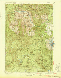
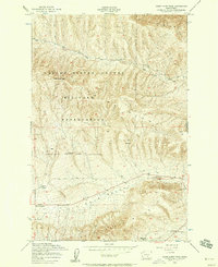
 1899 Ellensburg1957 Print · USGSCentral Washington at the turn of the century shows a landscape of growing river towns and high ridges. Researchers can trace early railroad expansion along the Northern Pacific RR or locate rural outposts like Tampico, Ahtanum, and Nile.
 - 1901 Map of Ellensburg
 1901 Ellensburg1901 Print · USGSCentral Washington at the turn of the century shows a landscape shaped by river valleys and high ridges. Trace the early Northern Pacific Railway line through Ellensburg and the remote outposts of Nile and Tampico.6 unique versions available
 - 1901 Map of Snoqualmie Pass, 1956 Print
 1901 Snoqualmie Pass1956 Print · USGSSnoqualmie Pass and the central Cascades are seen here during the early years of transcontinental rail expansion. Trace the original Northern Pacific route through the Stampede Tunnel and past early mountain stops like Easton, Hyak, and Ronald.2 unique versions available
 - 1902 Map of Mount Aix
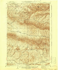
 1902 Mount Aix1902 Print · USGSThe eastern Cascades around Yakima are captured here at the start of the twentieth century, showing a high-country landscape of early mining and pack trails. Genealogists and historians can locate the site of Fife's Mine, the settlement at Goose Prairie, and early landmarks like Lake House.
 - 1903 Map of Snoqualmie
 1903 Snoqualmie1903 Print · USGSThe Cascade Range at the turn of the century was a landscape of high-altitude rail engineering and timber potential. Trace the Northern Pacific RR through the Stampede Tunnel to early mountain settlements like Easton and Lester.6 unique versions available
 - 1904 Map of Mt Aix
 1904 Mt Aix1904 Print · USGSThe high mountain passes and forest reserves of the Central Cascades are captured here at the start of the century. Genealogists and researchers can trace early outposts like Russell Ranch and the Lake House, or locate the Fires Mine and remote Mc Allister Meadows.6 unique versions available
 - 1904 Map of Mount Adams, 1956 Print
 1904 Mount Adams1956 Print · USGSThe South Cascades and the Yakima Indian Reservation are captured here at the start of the twentieth century, during a time of early timber and ranching growth. Researchers can trace historic mills and stock routes through Glenwood, Hoppers Mill, and Parrotts Bridge.2 unique versions available
 - 1907 Map of Mount Adams
 1907 Mount Adams1907 Print · USGSThe high Cascades and the western reaches of the Yakima Reservation are mapped here in the early twentieth century. Researchers can locate early homesteads and industry like Kesslers Ranch, Lacroux Mill, and Glenwood among the glacial peaks.5 unique versions available
 - 1910 Map of Zillah
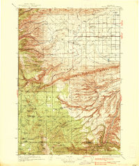
 1910 Zillah1910 Print · USGSThe Yakima River valley was transforming into an agricultural hub in the early 1900s as irrigation projects expanded. Researchers can trace the path of the Northern Pacific railroad through Toppenish and Wapato, or locate early sites like the Sawmill and Bluelight.3 unique versions available
 - 1915 Map of Prosser, 1957 Print
 1915 Prosser1957 Print · USGSThe Yakima Valley thrived as a rail and irrigation hub during the early twentieth century. Researchers can trace the layout of early schools and family-named homesteads like Orchard Ridge School, Snively Ranch, and the town of Prosser.
 - 1917 Map of Priest Rapids
 1917 Priest Rapids1917 Print · USGSThe Columbia River bend and the high country of the Rattlesnake Hills are captured here during a period of early ranching and river industry. Genealogists and historians can locate remote outposts like Figure 2 Ranch, the site of Vernita, and the vital Richmond Ferry.2 unique versions available
 - 1917 Map of Prosser
 1917 Prosser1917 Print · USGSBenton and Yakima counties thrive in the late teens as irrigation and rail lines transform the desert floor into a budding agricultural hub. Researchers can trace early family homesteads like Benson Ranch and numerous rural landmarks like Buena Vista School and the Gas Well.2 unique versions available
 - 1924 Map of Mt Rainier
 1924 Mt Rainier1924 Print · USGSLewis and Pierce counties are shown during the mid-twenties, when the timber economy and the National Forest system were establishing their regional footprint. Genealogists and researchers can locate early rural schools like Cline School and Cora School or trace the network of forest outposts like Packwood Ranger Sta.6 unique versions available
 - 1926 Map of Steamboat Mtn, 1954 Print
 1926 Steamboat Mtn1954 Print · USGSThe northern Cascades in the mid-twenties are shown here as a wilderness of timber and ice during the early years of the National Forest system. Researchers can locate remote outposts like Tower Rock Ranger Sta, the historic Williams Mine, and forgotten sites like Graveyard Camp.3 unique versions available
 - 1928 Map of Mt Rainier
 1928 Mt Rainier1928 Print · USGSThe Washington Cascades in the late 1920s reveal a landscape of glaciated peaks and emerging river valley communities. Trace early mountaineering and park history at Longmire, or locate family-named landmarks like Schooley and the Cora School near the Cowlitz River.6 unique versions available
 - 1931 Map of Steamboat Mtn
 1931 Steamboat Mtn1931 Print · USGSSkamania and Lewis Counties appear as a managed wilderness of national forests in the years before World War II. Researchers can trace the early footprint of forest management at the Cispus Lookout Sta and remote sites like Graveyard Camp or Buckhorn Camp.2 unique versions available
 - 1936 Map of Yakima East
 1936 Yakima East1936 Print · USGSYakima and the Moxee Valley are shown here in the mid-1930s as the regional irrigation and rail networks were fully established. Genealogists and local historians can trace family locations near Pease Ranch, Moxee City, and schools like Central Sch.
 - 1936 Map of Hog Ranch Buttes
 1936 Hog Ranch Buttes1936 Print · USGSYakima and Kittitas counties are captured here in the mid-thirties, showing a vast ranching landscape defined by high ridges and deep canyons. Family historians can trace homesteads like Holmes Ranch and Meeboer Ranch, or locate local landmarks like Taylor Sch.
 - 1937 Map of White Swan
 1937 White Swan1937 Print · USGSThe Yakima Indian Reservation in the mid-1930s reveals a landscape of high ridges meeting an emerging irrigation frontier. Genealogists and historians can trace early school sites like Medicine Valley Sch, the rail-stop at Harrah, and the historic grounds of Fort Simcoe.3 unique versions available
 - 1941 Map of Black Rock Spring
 1941 Black Rock Spring1941 Print · USGSThe high desert of Yakima and Kittitas Counties comes to life in the years before the war, showing a landscape shaped by ranching and deep basalt canyons. Researchers can trace historic family holdings like the Stewart Ranch and Coffin Ranch, or locate the isolated Taylor Sch.2 unique versions available
 - 1941 Map of Yakima East
 1941 Yakima East1941 Print · USGSThe Yakima Valley was a hub of irrigation and rail transport in the early 1940s, as intensive canal networks reshaped the landscape. Local historians can trace family homesteads along Beaudry Road and Charon Rd, or locate the First Reformed Ch and the State Fairgrounds.2 unique versions available
 - 1948 Map of Cairn Hope Peak, 1958 Print
 1948 Cairn Hope Peak1958 Print · USGSYakima County ranching lands and military territory are surveyed here shortly after the war. Researchers can trace early family homesteads like Taylor Ranch and Meeboer Ranch, alongside landmarks such as Black Rock Cem.3 unique versions available
 - 1948 Map of Emerson Nipple, 1958 Print
 1948 Emerson Nipple1958 Print · USGSThe high desert south of the Columbia River comes into focus in this late-1940s survey, showing a landscape defined by massive ridges and vital water sources. Researchers can locate remote outposts like Roberts Ranch and trace the early route of the Chicago Milwaukee St Paul and Pacific railroad.3 unique versions available
 - 1948 Map of Priest Rapids, 1958 Print
 1948 Priest Rapids1958 Print · USGSThe Columbia River corridor is captured here in the late 1940s, split between the Yakima Firing Center Military Reservation and the Wahluke Slope. Researchers can trace the river's path through Priest Rapids, locating family sites like Stewart Ranch and the early Powerhouse.2 unique versions available
 - 1950 Map of Yakima, 1951 Print
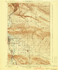
 1950 Yakima1951 Print · USGSThe Yakima Valley and the towering Cascades meet in this mid-century survey of South Central Washington. Genealogists and local historians can trace the irrigation-era growth of Yakima, the historic Fort Simcoe outpost, and the White Swan Mission on the Yakima Indian Reservation.
Showing maps 1-25 of 737
Top cities of Yakima County
- Yakima historical maps
- Sunnyside historical maps
- Grandview historical maps
- Toppenish historical maps
- Selah historical maps
- Union Gap historical maps
See more
Frequently asked questions
- What are the different types of historical maps available for Yakima County?
- What is the oldest map of Yakima County?
- Where can I purchase historical maps of Yakima County for my home or office?
- Where can I download high-res historical maps of Yakima County?
- Are there historical topographic maps available for Yakima County?
- Is there historical aerial imagery available for Yakima County?
- Where are historical maps of Yakima County sourced from?