1900-1909 Maps of Kanawha County, West Virginia
Explore 19 historic maps of Kanawha County from 1900-1909. These maps offer a rare glimpse into what life looked like during the 1900s — showing old roads, neighborhoods, homes, and landmarks that have changed or disappeared over time.
Whether you're researching your family's past, planning a metal detecting trip, or studying how Kanawha County's landscape evolved across the 1900s, these high-resolution maps are a powerful tool for exploring the history of this region.
- Focus on a specific era: All maps on this page are from the 1900s, giving you a focused view of this time period.
- See what’s changed: Compare century-old streets, trails, and buildings to today's modern landscape using overlays and satellite layers.
- Research with precision: Use these maps for genealogy, historical research, land use analysis, or educational projects.
- View, download, or print: Maps are fully viewable online in high resolution, and can be downloaded or printed for your own records.
Start exploring Kanawha County's history through authentic maps from the 1900s. This is your window into the past.
Kanawha County, WV maps
(19)- 1900 Map of Kanawha Falls
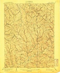
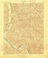
 1900 Kanawha Falls1900 Print · USGSThe Kanawha and Elk rivers converge here at the turn of the century as the coal and rail industries were rapidly transforming the West Virginia landscape. Genealogists and historians can trace riverside settlements like Montgomery and Coalburg or follow the paths of the Chesapeake and Ohio RR and early river navigation at Lock 2.
 - 1901 Map of Kanawha Falls
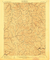
 1901 Kanawha Falls1901 Print · USGSWest Virginia's coal and rail heartland is captured here at the end of the nineteenth century, as river navigation and railroads transformed the Kanawha Valley. Genealogists and historians can trace the early footprints of Montgomery, find family sites near Kanawha Falls, and locate landmarks like Hawks Nest or Powellton.3 unique versions available
 - 1902 Map of Raleigh
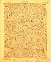
 1902 Raleigh1902 Print · USGSRaleigh County and the New River Gorge were entering their industrial peak when this survey was conducted in the late nineteenth century. Researchers can trace the early rail network of the CHESAPEAKE AND OHIO RR through booming towns like Thurmond, Beury, and East Sewell.3 unique versions available
 - 1906 Map of Kenna, 1959 Print
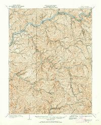
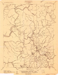
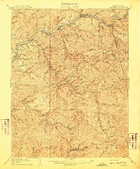
 1906 Kenna1959 Print · USGSThe West Virginia hills north of Charleston appear in this early century survey of the Jackson and Kanawha county border. Researchers can locate early homesteads and community hubs like Sissonville, the Emma Belle School, and Staats Mills.
 - 1906 Map of Winfield, 1961 Print
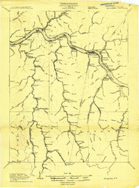
 1906 Winfield1961 Print · USGSThe Kanawha River valley at the turn of the century shows a landscape defined by river locks and the growing influence of the railroad. Genealogists and historians can trace old homesteads and landings from Redhouse Shoals to the small village of Confidence.
 - 1906 Map of Otter, 1961 Print
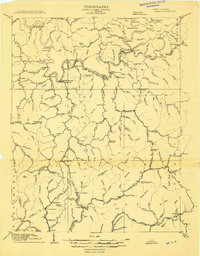
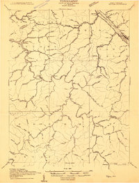
 1906 Otter1961 Print · USGSCentral West Virginia at the start of the twentieth century shows a landscape of deep hollows and high ridges before modern highways. Researchers can trace early settlements and family homesteads near Ivydale, Newton, and the remote Redhouse Siding along the Elk River.
 - 1906 Map of Walton, 1961 Print
 1906 Walton1961 Print · USGSRoane County at the dawn of the twentieth century shows a landscape of river-fed valleys and milling hamlets. Genealogists can trace family roots through historic settlements like Walton, Gandeeville, and Looneyville or locate long-standing landmarks like Mt Hermon Church.
 - 1907 Map of Kenna
 1907 Kenna1907 Print · USGSThe hill country of Jackson and Kanawha counties is captured here in the early twentieth century as a landscape of isolated valley farms and ridge-top communities. Genealogists can trace family footprints through rural centers like Sissonville, Staats Mills, and White Chapel.3 unique versions available
 - 1907 Map of Otter
 1907 Otter1907 Print · USGSCentral West Virginia at the turn of the century shows a landscape defined by its river valleys and new industrial rails. Genealogists can trace family homes near Newton, Linden, and Minnora, or follow the path of the Coal and Coke R R through Ivydale.3 unique versions available
 - 1907 Map of Walton
 1907 Walton1907 Print · USGSRoane County at the dawn of the twentieth century is a landscape of winding river valleys and isolated hilltop settlements. Genealogists and historians can trace family-named landmarks and early industry at Shamblings Mills, Osbornes Mills, and Mt Hermon Church.3 unique versions available
 - 1907 Map of Clendenin, 1962 Print
 1907 Clendenin1962 Print · USGSThe Elk River valley and its steep ridge-and-hollow terrain are captured here in the early 1900s as railroads expanded into the coalfields. Trace old river crossings at Jarretts Ford or locate remote hillside settlements like Putney, Quick, and Kendalia.2 unique versions available
 - 1908 Map of Winfield
 1908 Winfield1908 Print · USGSThe Kanawha River valley at the turn of the century shows a landscape defined by river traffic and rail expansion. Genealogists and historians can trace riverside settlements like Winfield and Buffalo, or find lost rail stops and river locks including Lock No 10 and Black Betsey.3 unique versions available
 - 1908 Map of Clay
 1908 Clay1908 Print · USGSThe river and rail network of central West Virginia dominates this territory at the start of the century. Trace early Appalachian settlement patterns through the COAL AND COKE RR and rural landmarks like Rosetta School and Big Sycamore Eldorado PO.2 unique versions available
 - 1908 Map of Fayetteville
 1908 Fayetteville1908 Print · USGSFayette County was at the heart of the coal and rail boom when this survey was conducted. Researchers can trace the early industrial footprint of the Chesapeake and Ohio Railroad through settlements like Ansted, Gauley Bridge, and Kanawha Falls.
 - 1908 Map of Montgomery
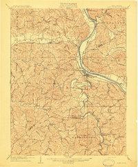
 1908 Montgomery1908 Print · USGSWest Virginia's industrial heartland is revealed in the early twentieth century as a dense network of coal towns and river locks. Trace the rail-and-river economy through Cabin Creek Junction, the Wheeler Islands, and the namesake town of Montgomery.
 - 1909 Map of Charleston
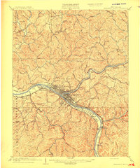 1909 Charleston1909 Print · USGSThe Kanawha and Elk rivers converge at the turn of the century, showing a region during a period of rapid industrial expansion. Trace old rail lines and rural landmarks like Mason Sta Graham Mines P.O. and the Morning Star School Church.6 unique versions available
 - 1909 Map of Clendenin
 1909 Clendenin1909 Print · USGSKanawha County’s rugged river corridors and rail-linked mining towns are captured here in the first decade of the twentieth century. Genealogists and historians can trace family locations near Jarretts Ford, Dry Ridge School, and the remote settlement of Blakeley.5 unique versions available
 - 1909 Map of Peytona
 1909 Peytona1909 Print · USGSBoone and Kanawha Counties are shown here during a period of industrial expansion along the river forks and mountain ridges. Researchers can trace early railroad sidings and post offices at Winifrede Jct, Lewiston PO, and the riverside community of Peytona.
 - 1909 Map of Saint Albans
 1909 Saint Albans1909 Print · USGSThe Kanawha and Coal Rivers converge at the height of the river-and-rail era, revealing a landscape of busy lock systems and mountain settlements. Researchers can trace family roots through numerous rural landmarks like Blacks School, Scott Depot, and Alum Creek Rome PO.2 unique versions available
End of results
Showing maps 1-19 of 19
Top cities of Kanawha County
- Charleston historical maps
- South Charleston historical maps
- St. Albans historical maps
- Dunbar historical maps
- Marmet historical maps
- Chesapeake historical maps
See more
Frequently asked questions
- What are the different types of historical maps available for Kanawha County?
- What is the oldest map of Kanawha County?
- Where can I purchase historical maps of Kanawha County for my home or office?
- Where can I download high-res historical maps of Kanawha County?
- Are there historical topographic maps available for Kanawha County?
- Is there historical aerial imagery available for Kanawha County?
- Where are historical maps of Kanawha County sourced from?