1980s Maps of Kanawha County, West Virginia
Explore 3 historic maps of Kanawha County from the 1980s. These maps offer a rare glimpse into what life looked like during the 1980s — showing old roads, neighborhoods, homes, and landmarks that have changed or disappeared over time.
Whether you're researching your family's past, planning a metal detecting trip, or studying how Kanawha County's landscape evolved across the 1980s, these high-resolution maps are a powerful tool for exploring the history of this region.
- Focus on a specific era: All maps on this page are from the 1980s, giving you a focused view of this time period.
- See what’s changed: Compare century-old streets, trails, and buildings to today's modern landscape using overlays and satellite layers.
- Research with precision: Use these maps for genealogy, historical research, land use analysis, or educational projects.
- View, download, or print: Maps are fully viewable online in high resolution, and can be downloaded or printed for your own records.
Start exploring Kanawha County's history through authentic maps from the 1980s. This is your window into the past.
Kanawha County, WV maps
(3)- 1982 Map of Beckley, 1984 Print
 1982 Beckley1984 Print · USGSSouthern West Virginia coal country is captured here in the early eighties as industrial heritage met new wilderness protections. Genealogists and historians can trace the rail-linked communities of Beckley, Oak Hill, and the coal camps near Macdonald.
 - 1984 Map of Ripley
 1984 Ripley1984 Print · USGSThe West Virginia riverfront and interior highlands are captured here in the mid-eighties as energy production reshaped the landscape. Researchers can trace the Ohio River industrial corridor through Ravenswood or locate smaller inland communities like Gandeeville and Reedy.
 - 1984 Map of Charleston
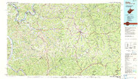
 1984 Charleston1984 Print · USGSWest Virginia's capital and the industrial Kanawha Valley are shown here in the mid-eighties as modern interstates began to reshape the region. Local researchers can locate family-named landmarks like Reamer (Sybial PO) and institutional anchors like West Virginia State College.2 unique versions available
End of results
Showing maps 1-3 of 3
Top cities of Kanawha County
- Charleston historical maps
- South Charleston historical maps
- St. Albans historical maps
- Dunbar historical maps
- Marmet historical maps
- Chesapeake historical maps
See more
Frequently asked questions
- What are the different types of historical maps available for Kanawha County?
- What is the oldest map of Kanawha County?
- Where can I purchase historical maps of Kanawha County for my home or office?
- Where can I download high-res historical maps of Kanawha County?
- Are there historical topographic maps available for Kanawha County?
- Is there historical aerial imagery available for Kanawha County?
- Where are historical maps of Kanawha County sourced from?