1910s Maps of Logan County, West Virginia
Explore 11 historic maps of Logan County from the 1910s. These maps offer a rare glimpse into what life looked like during the 1910s — showing old roads, neighborhoods, homes, and landmarks that have changed or disappeared over time.
Whether you're researching your family's past, planning a metal detecting trip, or studying how Logan County's landscape evolved across the 1910s, these high-resolution maps are a powerful tool for exploring the history of this region.
- Focus on a specific era: All maps on this page are from the 1910s, giving you a focused view of this time period.
- See what’s changed: Compare century-old streets, trails, and buildings to today's modern landscape using overlays and satellite layers.
- Research with precision: Use these maps for genealogy, historical research, land use analysis, or educational projects.
- View, download, or print: Maps are fully viewable online in high resolution, and can be downloaded or printed for your own records.
Start exploring Logan County's history through authentic maps from the 1910s. This is your window into the past.
Logan County, WV maps
(11)- 1910 Map of Pineville
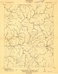 1910 Pineville1910 Print · USGSWyoming County at the dawn of the twentieth century was a landscape of deep hollows and high ridges connected by the Guyandot River. Genealogists can trace family footprints in early settlements like Baileysville, Oceana, and near the old McDonald Mill.2 unique versions available
 - 1910 Map of Bald Knob
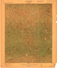
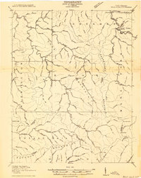 1910 Bald Knob1910 Print · USGSSouthern West Virginia in the early twentieth century was a landscape of remote mountain gaps and emerging rail corridors. Genealogists and historians can trace early settlements like Jarrolds Valley and Van, or locate historic crossing points like Walnut Gap and Indian Gap.2 unique versions available
 - 1910 Map of Holden
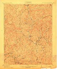
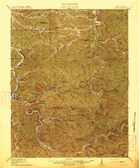
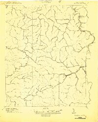 1910 Holden1910 Print · USGSLogan County’s rugged coalfield landscape is captured here in the early 1900s as development followed the winding Guyandot River. Researchers can trace old family-named settlements like Mc Cloud, Whirlwind, and Halcyon tucked into the hollows.
 - 1911 Map of Madison
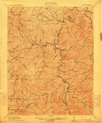 1911 Madison1911 Print · USGSBoone and Lincoln counties appear here in the early twentieth century as the rail network began to reshape the coal-bearing valleys. Researchers can trace early infrastructure through the Chesapeake and Ohio line and settlements like Madison, Uneeda, and Danville.2 unique versions available
 - 1912 Map of Bald Knob
 1912 Bald Knob1912 Print · USGSBoone County and the surrounding coalfields are captured in the early twentieth century as rail lines began to penetrate the deep Appalachian hollows. Genealogists and historians can trace early settlements at Whitesville, Jarrolds Valley, and Gordon alongside the growing C. and O. R. R. line.3 unique versions available
 - 1912 Map of Gilbert
 1912 Gilbert1912 Print · USGSThe Guyandot River valley and the industrial Tug Fork corridor define this region in the early nineteen-hundreds. Researchers can trace rail-tied settlements like Wharncliffe and War Eagle or find rural landmarks such as Twisted Gun Gap and North Spring.2 unique versions available
 - 1912 Map of Pineville
 1912 Pineville1912 Print · USGSWyoming County at the dawn of the twentieth century shows a landscape of river-valley settlements and high ridges. Researchers can locate early homesteads and community centers like Baileysville, Pineville, and the remote Sun Hill along the Huff Mountain range.
 - 1912 Map of Holden
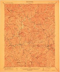
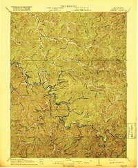
 1912 Holden1912 Print · USGSSouthern West Virginia’s coal and rail landscape comes into focus at the dawn of the twentieth century. Genealogists and local historians can trace family-named hollows and early settlements like Holden, Whirlwind, and Chapmanville along the Guyandot River.
 - 1913 Map of Logan
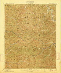
 1913 Logan1913 Print · USGSThe West Virginia coalfields are seen here during their early industrial expansion in the years before the Great War. Genealogists and researchers can trace family landmarks and rail-side settlements like Logan, Pecks Mill, and Ethel along the Guyandot River.3 unique versions available
 - 1915 Map of Matewan
 1915 Matewan1915 Print · USGSThe industrial coalfields of Mingo County and the Kentucky border are documented here during the height of the early twentieth-century boom. Genealogists and historians can trace rail-side communities and mining operations like Thacker Mines, Red Jacket, and the Blackberry Fork School.
 - 1917 Map of Matewan
 1917 Matewan1917 Print · USGSThe Tug Fork valley in the 1910s was a bustling corridor of coal production and rail activity along the West Virginia and Kentucky border. Genealogists and historians can trace the foundations of coal-camp life at Thacker Mines, the winding Norfolk and Western RR, and local landmarks like the Hatfield School.2 unique versions available
End of results
Showing maps 1-11 of 11
Top cities of Logan County
- Mallory historical maps
- Logan historical maps
- Chapmanville historical maps
- Holden historical maps
- Man historical maps
- Accoville historical maps
See more
Frequently asked questions
- What are the different types of historical maps available for Logan County?
- What is the oldest map of Logan County?
- Where can I purchase historical maps of Logan County for my home or office?
- Where can I download high-res historical maps of Logan County?
- Are there historical topographic maps available for Logan County?
- Is there historical aerial imagery available for Logan County?
- Where are historical maps of Logan County sourced from?