1920s Maps of Logan County, West Virginia
Explore 10 historic maps of Logan County from the 1920s. These maps offer a rare glimpse into what life looked like during the 1920s — showing old roads, neighborhoods, homes, and landmarks that have changed or disappeared over time.
Whether you're researching your family's past, planning a metal detecting trip, or studying how Logan County's landscape evolved across the 1920s, these high-resolution maps are a powerful tool for exploring the history of this region.
- Focus on a specific era: All maps on this page are from the 1920s, giving you a focused view of this time period.
- See what’s changed: Compare century-old streets, trails, and buildings to today's modern landscape using overlays and satellite layers.
- Research with precision: Use these maps for genealogy, historical research, land use analysis, or educational projects.
- View, download, or print: Maps are fully viewable online in high resolution, and can be downloaded or printed for your own records.
Start exploring Logan County's history through authentic maps from the 1920s. This is your window into the past.
Logan County, WV maps
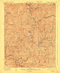
(10)- 1925 Map of Gilbert
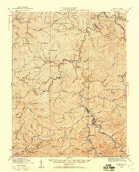
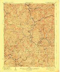 1925 Gilbert1925 Print · USGSSouthern West Virginia in the mid-twenties shows a landscape defined by steep hollows and a burgeoning coal-and-rail economy. Researchers can trace ancestral footprints at several family-named institutions like Hatfield School or find old mining hubs such as Wharncliffe and Glenalum.
 - 1926 Map of Holden, 1957 Print
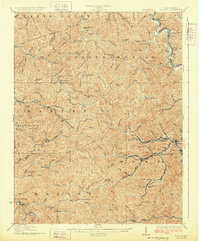
 1926 Holden1957 Print · USGSSouthern West Virginia in the mid-1920s shows a landscape of mountain schools and expanding rail networks. Researchers can trace dozens of early rural schools like Dave Dingess School and Hager School alongside rail hubs at Whitman Junction and Holden.
 - 1926 Map of Logan, 1963 Print
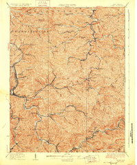
 1926 Logan1963 Print · USGSWest Virginia's southern coalfields are shown here in the mid-1920s, a period of intense industrial and rail development along the Guyandotte River. Researchers can trace the development of coal camps and local schools, from Pecks Mill and Clothier to the Crooked Creek School and Five Block Macneer PO.
 - 1927 Map of Pineville
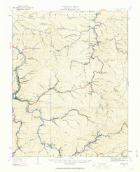
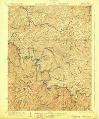
 1927 Pineville1927 Print · USGSWyoming County in the mid-twenties shows a landscape shaped by narrow hollows and the timber-driven expansion of the Virginian RR. Genealogists can trace early families through numerous rural landmarks like the Olinger School, Clear Fork PO, and Matheney School.2 unique versions available
 - 1927 Map of Gilbert
 1927 Gilbert1927 Print · USGSIn the late 1920s, southern West Virginia's mountain hollows were connected by narrow-gauge rails and family-centered school districts. Genealogists can trace family footprints through sites like the Craig Hatfield School, Wharncliffe, and War Eagle.4 unique versions available
 - 1928 Map of Holden
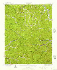
 1928 Holden1928 Print · USGSLogan County's coal-country heart is captured here in the late twenties, showing the peak of the mountain rail and mining economy. Researchers can trace the narrow-gauge lines and spurs serving Holden, Verdunville, and Whitman Junction, while locating family landmarks like the Dave Dingess School or Ellis Camp.2 unique versions available
 - 1928 Map of Logan
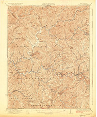
 1928 Logan1928 Print · USGSThe Guyandotte River valley and the southern coalfields are shown in detail during the late twenties. Genealogists can trace family homes near rural landmarks like Isom School, Pecks Mill, and the many station stops along the Chesapeake and Ohio railroad.3 unique versions available
 - 1928 Map of Matewan
 1928 Matewan1928 Print · USGSCoal and rail define the rugged borderlands of the West Virginia-Kentucky line in the late 1920s. Genealogists can trace family footprints at Puritan Mines, Matewan, and the many hollow schools like Hatfield Sch and Red Jacket Sch.4 unique versions available
 - 1928 Map of Bald Knob, 1956 Print
 1928 Bald Knob1956 Print · USGSBoone, Logan, and Raleigh counties are mapped here in the late twenties at the height of the coal-rail boom. You can trace early industrial rail lines like the Chesapeake and Ohio and locate vanished local landmarks like Bothwell Sch and Jackson (Bim PO).
 - 1929 Map of Madison, 1960 Print
 1929 Madison1960 Print · USGSThe Coal River valley in the late twenties reveals a landscape of industrial rail and rural schoolhouses. Genealogists can trace family footprints through numerous local sites like Julian, Uneeda, and Pine Grove Ch, or the many scattered schools such as Slabtown Sch.
End of results
Showing maps 1-10 of 10
Top cities of Logan County
- Mallory historical maps
- Logan historical maps
- Chapmanville historical maps
- Holden historical maps
- Man historical maps
- Accoville historical maps
See more
Frequently asked questions
- What are the different types of historical maps available for Logan County?
- What is the oldest map of Logan County?
- Where can I purchase historical maps of Logan County for my home or office?
- Where can I download high-res historical maps of Logan County?
- Are there historical topographic maps available for Logan County?
- Is there historical aerial imagery available for Logan County?
- Where are historical maps of Logan County sourced from?