1900-1909 Maps of Marion County, West Virginia
Explore 5 historic maps of Marion County from 1900-1909. These maps offer a rare glimpse into what life looked like during the 1900s — showing old roads, neighborhoods, homes, and landmarks that have changed or disappeared over time.
Whether you're researching your family's past, planning a metal detecting trip, or studying how Marion County's landscape evolved across the 1900s, these high-resolution maps are a powerful tool for exploring the history of this region.
- Focus on a specific era: All maps on this page are from the 1900s, giving you a focused view of this time period.
- See what’s changed: Compare century-old streets, trails, and buildings to today's modern landscape using overlays and satellite layers.
- Research with precision: Use these maps for genealogy, historical research, land use analysis, or educational projects.
- View, download, or print: Maps are fully viewable online in high resolution, and can be downloaded or printed for your own records.
Start exploring Marion County's history through authentic maps from the 1900s. This is your window into the past.
Marion County, WV maps
(5)- 1902 Map of Clarksburg
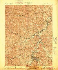 1902 Clarksburg1902 Print · USGSNorth-central West Virginia at the opening of the twentieth century was a bustling network of river-towns and turnpikes. Genealogists can trace family roots through coal-and-rail hubs like Shinnston and Lumberport or rural landmarks such as Sturms Mill and Pinnickinnick Mt.3 unique versions available
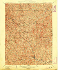
 - 1902 Map of Fairmont
 1902 Fairmont1902 Print · USGSMarion and Taylor Counties were hubs of coal and transit at the opening of the twentieth century, as the rail lines followed the winding rivers. Genealogists can trace early family settlements and work sites from the Tyrconnell Mines to rural Nebo Church and Boothsville.4 unique versions available
 - 1904 Map of Blacksville
 1904 Blacksville1904 Print · USGSThe West Virginia and Pennsylvania border comes alive in this survey from the early twentieth century. Researchers can trace the river economy along the Monongahela at Lock No. 13 or locate rural homesteads near Fairview Amos P.O. and Blacksville.3 unique versions available
 - 1905 Map of Mannington
 1905 Mannington1905 Print · USGSThe West Virginia-Pennsylvania borderlands are captured here at the start of the twentieth century, showing a landscape defined by deep ridges and rail-side commerce. Genealogists can trace family roots through locations like Hundred Church, Wadestown, and Brave P.O. along the state line.2 unique versions available
 - 1907 Map of Thornton
 1907 Thornton1907 Print · USGSPreston and Taylor counties are depicted here in the early years of the century as the rail industry reshaped the Appalachian highlands. Genealogists can trace family roots at specific landmarks like Summers Church, Knottsville, and Slabtown Schoolhouse along the Baltimore and Ohio RR corridor.2 unique versions available
End of results
Showing maps 1-5 of 5
Top cities of Marion County
- Fairmont historical maps
- Pleasant Valley historical maps
- Mannington historical maps
- Barrackville historical maps
- Rivesville historical maps
- Monongah historical maps
See more
Frequently asked questions
- What are the different types of historical maps available for Marion County?
- What is the oldest map of Marion County?
- Where can I purchase historical maps of Marion County for my home or office?
- Where can I download high-res historical maps of Marion County?
- Are there historical topographic maps available for Marion County?
- Is there historical aerial imagery available for Marion County?
- Where are historical maps of Marion County sourced from?