1920s Maps of Marion County, West Virginia
Explore 9 historic maps of Marion County from the 1920s. These maps offer a rare glimpse into what life looked like during the 1920s — showing old roads, neighborhoods, homes, and landmarks that have changed or disappeared over time.
Whether you're researching your family's past, planning a metal detecting trip, or studying how Marion County's landscape evolved across the 1920s, these high-resolution maps are a powerful tool for exploring the history of this region.
- Focus on a specific era: All maps on this page are from the 1920s, giving you a focused view of this time period.
- See what’s changed: Compare century-old streets, trails, and buildings to today's modern landscape using overlays and satellite layers.
- Research with precision: Use these maps for genealogy, historical research, land use analysis, or educational projects.
- View, download, or print: Maps are fully viewable online in high resolution, and can be downloaded or printed for your own records.
Start exploring Marion County's history through authentic maps from the 1920s. This is your window into the past.
Marion County, WV maps
(9)- 1923 Map of Blacksville, 1956 Print
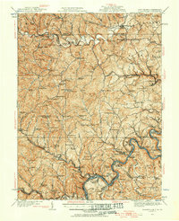 1923 Blacksville1956 Print · USGSMonongalia and Marion counties appear here during the early twentieth century as the coal and rail economy began to reshape the rural landscape. Researchers can find numerous family landmarks, from Town School and Olive Church to the industrial works at Montana Mines.
 - 1923 Map of Fairmont, 1956 Print
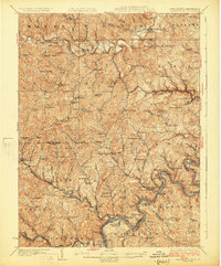
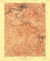
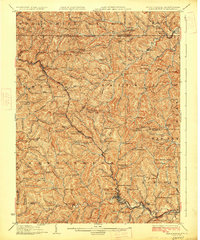
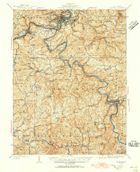 1923 Fairmont1956 Print · USGSMarion and Taylor counties are shown during the height of their rail and coal era in the early twentieth century. Researchers can trace family origins through dozens of named landmarks like Jane Memorial Church, T McConnell Mines, and the river crossing at Benton Ferry.2 unique versions available
 - 1923 Map of Mannington, 1956 Print
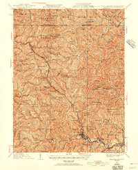 1923 Mannington1956 Print · USGSMannington and the surrounding hollows of Marion and Monongalia counties appear here in the early twenties as a dense network of rural life. Genealogists can trace family footprints through numerous small landmarks like Blackshire Chapel, Efaw Knob, and Glover Gap.
 - 1923 Map of Clarksburg, 1959 Print
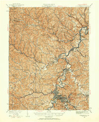 1923 Clarksburg1959 Print · USGSHarrison and Marion counties appear in the 1920s as a landscape of coal mines and mountain schoolhouses. Trace family roots at Bethel Church or Annabelle, and locate old industrial sites like Cook Mine and Straus Mill along the rivers.
 - 1925 Map of Blacksville
 1925 Blacksville1925 Print · USGSMonongalia and Marion Counties are shown in the mid-1920s, a period when rural life centered on a vast network of neighborhood schools and churches. Genealogists can trace family roots through specific landmarks like Stumptown School, Montana Mines, and Monumental Church.4 unique versions available
 - 1925 Map of Clarksburg
 1925 Clarksburg1925 Print · USGSHarrison County in the mid-twenties is a bustling corridor of coal mining and rail activity centered on the West Fork River. Genealogists can trace family roots through dozens of named rural schools like Lower Davisson Run School or locate vanished industrial sites like Ocean Mine and Sturms Mill.3 unique versions available
 - 1926 Map of Fairmont
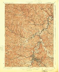
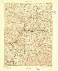
 1926 Fairmont1926 Print · USGSMarion and Taylor counties are shown during the mid-twenties when coal mining and the rail industry shaped the river valleys. Researchers can locate vanished landmarks like the Tyrconnell Mines and community centers such as Pruntytown and Mt Zion Church.3 unique versions available
 - 1926 Map of Thornton
 1926 Thornton1926 Print · USGSPreston and Taylor counties show a dense network of mountain settlements and rail corridors in the mid-1920s. Genealogists can locate family landmarks such as Slabcamp Church, the Pell School, and rail-side towns like Tunnelton or Newburg.2 unique versions available
 - 1926 Map of Mannington
 1926 Mannington1926 Print · USGSNorthern West Virginia and the Pennsylvania borderlands are shown here in the 1920s during a period of steady rural growth. Genealogists can trace family names through dozens of upland sites like Saint Cloud, Glover Gap, and the uniquely named The Little Red Church.2 unique versions available
End of results
Showing maps 1-9 of 9
Top cities of Marion County
- Fairmont historical maps
- Pleasant Valley historical maps
- Mannington historical maps
- Barrackville historical maps
- Rivesville historical maps
- Monongah historical maps
See more
Frequently asked questions
- What are the different types of historical maps available for Marion County?
- What is the oldest map of Marion County?
- Where can I purchase historical maps of Marion County for my home or office?
- Where can I download high-res historical maps of Marion County?
- Are there historical topographic maps available for Marion County?
- Is there historical aerial imagery available for Marion County?
- Where are historical maps of Marion County sourced from?