1990s Maps of Marion County, West Virginia
Explore 4 historic maps of Marion County from the 1990s. These maps offer a rare glimpse into what life looked like during the 1990s — showing old roads, neighborhoods, homes, and landmarks that have changed or disappeared over time.
Whether you're researching your family's past, planning a metal detecting trip, or studying how Marion County's landscape evolved across the 1990s, these high-resolution maps are a powerful tool for exploring the history of this region.
- Focus on a specific era: All maps on this page are from the 1990s, giving you a focused view of this time period.
- See what’s changed: Compare century-old streets, trails, and buildings to today's modern landscape using overlays and satellite layers.
- Research with precision: Use these maps for genealogy, historical research, land use analysis, or educational projects.
- View, download, or print: Maps are fully viewable online in high resolution, and can be downloaded or printed for your own records.
Start exploring Marion County's history through authentic maps from the 1990s. This is your window into the past.
Marion County, WV maps
(4)- 1997 Map of Fairmont West, 2002 Print
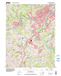 1997 Fairmont West2002 Print · USGSFairmont and the Monongahela River valley are captured here in the late twentieth century as the region transitioned from its industrial roots. Researchers can trace family sites at Evergreen Cemetery, visit the State Teachers College, or locate numerous coal-era sites such as former mines near Monongah.
 - 1997 Map of Rivesville, 2002 Print
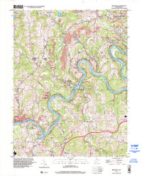 1997 Rivesville2002 Print · USGSThe Monongahela River valley north of Fairmont thrived on coal and river transport during the late twentieth century. Genealogists can trace family roots through numerous former mine sites and local landmarks like Montana (Montana Mines PO), Arnettsville Sch, and Pricketts Fort State Park.
 - 1998 Map of Hundred, 2000 Print
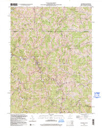 1998 Hundred2000 Print · USGSThe borderlands of northern West Virginia come to life in the late nineties, centered on the valley crossroads of Hundred. Genealogists can trace family landmarks like the McNicholas Cem and historic community hubs including Thomas Chapel and Cusicks Crossing.
 - 1999 Map of Fairmont East, 2000 Print
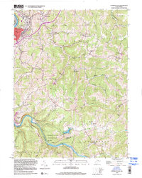 1999 Fairmont East2000 Print · USGSMarion County hill country and river valleys are documented here at the close of the century. Genealogists can trace family landmarks like Maple Grove Cem and rural centers such as Bunners Ridge Ch or Meadowdale Sch.
End of results
Showing maps 1-4 of 4
Top cities of Marion County
- Fairmont historical maps
- Pleasant Valley historical maps
- Mannington historical maps
- Barrackville historical maps
- Rivesville historical maps
- Monongah historical maps
See more
Frequently asked questions
- What are the different types of historical maps available for Marion County?
- What is the oldest map of Marion County?
- Where can I purchase historical maps of Marion County for my home or office?
- Where can I download high-res historical maps of Marion County?
- Are there historical topographic maps available for Marion County?
- Is there historical aerial imagery available for Marion County?
- Where are historical maps of Marion County sourced from?