1920s Maps of Monroe County, West Virginia
Explore 7 historic maps of Monroe County from the 1920s. These maps offer a rare glimpse into what life looked like during the 1920s — showing old roads, neighborhoods, homes, and landmarks that have changed or disappeared over time.
Whether you're researching your family's past, planning a metal detecting trip, or studying how Monroe County's landscape evolved across the 1920s, these high-resolution maps are a powerful tool for exploring the history of this region.
- Focus on a specific era: All maps on this page are from the 1920s, giving you a focused view of this time period.
- See what’s changed: Compare century-old streets, trails, and buildings to today's modern landscape using overlays and satellite layers.
- Research with precision: Use these maps for genealogy, historical research, land use analysis, or educational projects.
- View, download, or print: Maps are fully viewable online in high resolution, and can be downloaded or printed for your own records.
Start exploring Monroe County's history through authentic maps from the 1920s. This is your window into the past.
Monroe County, WV maps
(7)- 1921 Map of Alderson
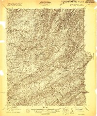
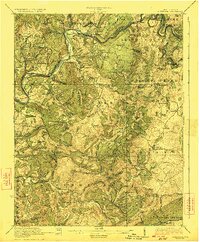
 1921 Alderson1921 Print · USGSThe Greenbrier River valley and the West Virginia highlands come alive in the early 1920s, showing the region's rail-dependent economy and rural school networks. Researchers can trace family roots at Nickels Mill, Spider Den School, and the settlement of Sinks Grove.3 unique versions available
 - 1921 Map of Ronceverte
 1921 Ronceverte1921 Print · USGSThe West Virginia and Virginia borderlands come alive in this early 1920s record of the Greenbrier Valley and Allegheny ridges. Genealogists can trace family roots through numerous local landmarks like Organ Cave, Red Mill, and the Highland Green School.2 unique versions available
 - 1923 Map of Ronceverte
 1923 Ronceverte1923 Print · USGSSoutheast West Virginia in the early twenties is a landscape of mountain ridges and remote hollows. Genealogists can trace the rural communities of Gap Mills and Sweet Springs, alongside dozens of landmarks like Organ Cave and Schley School.4 unique versions available
 - 1923 Map of Pearisburg
 1923 Pearisburg1923 Print · USGSThe West Virginia and Virginia state line follows the high crest of Peters Mountain in the early 1920s. Genealogists can trace a remarkable concentration of rural education and faith at sites like Oak Hill School and Green Valley Church.3 unique versions available
 - 1923 Map of Waiteville
 1923 Waiteville1923 Print · USGSThe mountain border between West Virginia and Virginia comes to life in the early 1920s, centered on the settlement of Waiteville. Local historians can trace the Norfolk and Western Ry line as it snakes along Potts Cr beneath Peters Mountain.2 unique versions available
 - 1923 Map of Alderson
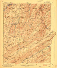
 1923 Alderson1923 Print · USGSMonroe and Greenbrier Counties are shown here in the early 1920s, a landscape defined by mineral springs and a dense network of rural schoolhouses. Researchers can locate dozens of local sites like Hokes Mill, Sinks Grove P O, and the Spider Den School.3 unique versions available
 - 1925 Map of Peterstown
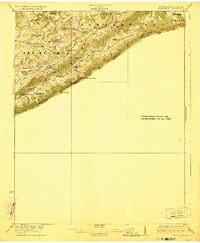
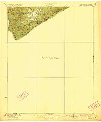
 1925 Peterstown1925 Print · USGSThe border of West Virginia and Virginia is captured in the mid-1920s, dominated by the winding path of the New River and the steep slopes of Peters Mtn. Genealogists can trace family locations near Mercers Saltworks, Wills Sta Willowton PO, and the Scratchgravel School.
End of results
Showing maps 1-7 of 7
Top cities of Monroe County
Frequently asked questions
- What are the different types of historical maps available for Monroe County?
- What is the oldest map of Monroe County?
- Where can I purchase historical maps of Monroe County for my home or office?
- Where can I download high-res historical maps of Monroe County?
- Are there historical topographic maps available for Monroe County?
- Is there historical aerial imagery available for Monroe County?
- Where are historical maps of Monroe County sourced from?