1970s Maps of Wayne County, West Virginia
Explore 6 historic maps of Wayne County from the 1970s. These maps offer a rare glimpse into what life looked like during the 1970s — showing old roads, neighborhoods, homes, and landmarks that have changed or disappeared over time.
Whether you're researching your family's past, planning a metal detecting trip, or studying how Wayne County's landscape evolved across the 1970s, these high-resolution maps are a powerful tool for exploring the history of this region.
- Focus on a specific era: All maps on this page are from the 1970s, giving you a focused view of this time period.
- See what’s changed: Compare century-old streets, trails, and buildings to today's modern landscape using overlays and satellite layers.
- Research with precision: Use these maps for genealogy, historical research, land use analysis, or educational projects.
- View, download, or print: Maps are fully viewable online in high resolution, and can be downloaded or printed for your own records.
Start exploring Wayne County's history through authentic maps from the 1970s. This is your window into the past.
Wayne County, WV maps
(6)- 1971 Map of Louisa, 1973 Print
 1971 Louisa1973 Print · USGSThe tri-state border region of Kentucky and West Virginia is captured here in the early seventies as the river-and-rail economy shaped the valley. Genealogists can trace family names at Greenlawn Cem or McClure Cem, and locate rural landmarks like Old Pleasant Ch and the hamlet of Saltpetre.4 unique versions available
 - 1971 Map of Fallsburg, 1973 Print
 1971 Fallsburg1973 Print · USGSIn the early 1970s, the rugged borderlands of Lawrence County were a complex network of rail lines and creek-side settlements. Researchers can trace the legacy of family homesteads and industry through labels for the Covered Bridge, Garrett Chapel, and the coal-and-oil works of the Big Sandy River valley.4 unique versions available
 - 1972 Map of Winslow, 1973 Print
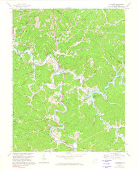
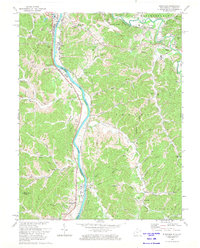
 1972 Winslow1973 Print · USGSWestern West Virginia hill country is captured here during the early seventies just as the terrain began to change. Researchers can trace the footprint of the area before the inundation of Beech Fork Lake, identifying sites like Winslow, Davis Chapel, and the McComas Sch.4 unique versions available
 - 1972 Map of Lavalette, 1974 Print
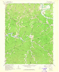
 1972 Lavalette1974 Print · USGSWayne County was undergoing significant change in the early seventies as new water management projects took shape. Genealogists and local historians can trace the foundations of Lavalette and Dickson before the rise of Beech Fork Lake submerged the valley.3 unique versions available
 - 1972 Map of Burnaugh, 1974 Print
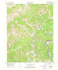
 1972 Burnaugh1974 Print · USGSThe river and rail corridor of the Big Sandy River defines this 1970s borderland between Kentucky and West Virginia. Genealogists and local historians can trace family locations through numerous sites like Lockwood Cem, Miller Chapel, and the riverside rail stops at Burnaugh.3 unique versions available
 - 1976 Map of Huntington, 1979 Print
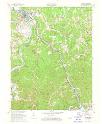
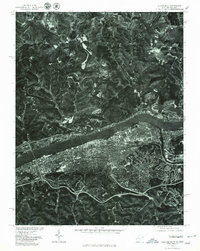 1976 Huntington1979 Print · USGSThe Huntington riverfront and neighboring Ohio shorelines appear in sharp aerial detail during the mid-seventies. Trace the urban footprint of Huntington across from Proctorville or follow the path of Symmes Creek through the northern hills.
End of results
Showing maps 1-6 of 6
Top cities of Wayne County
Frequently asked questions
- What are the different types of historical maps available for Wayne County?
- What is the oldest map of Wayne County?
- Where can I purchase historical maps of Wayne County for my home or office?
- Where can I download high-res historical maps of Wayne County?
- Are there historical topographic maps available for Wayne County?
- Is there historical aerial imagery available for Wayne County?
- Where are historical maps of Wayne County sourced from?