1950s Maps of Wayne County, West Virginia
Explore 15 historic maps of Wayne County from the 1950s. These maps offer a rare glimpse into what life looked like during the 1950s — showing old roads, neighborhoods, homes, and landmarks that have changed or disappeared over time.
Whether you're researching your family's past, planning a metal detecting trip, or studying how Wayne County's landscape evolved across the 1950s, these high-resolution maps are a powerful tool for exploring the history of this region.
- Focus on a specific era: All maps on this page are from the 1950s, giving you a focused view of this time period.
- See what’s changed: Compare century-old streets, trails, and buildings to today's modern landscape using overlays and satellite layers.
- Research with precision: Use these maps for genealogy, historical research, land use analysis, or educational projects.
- View, download, or print: Maps are fully viewable online in high resolution, and can be downloaded or printed for your own records.
Start exploring Wayne County's history through authentic maps from the 1950s. This is your window into the past.
Wayne County, WV maps
(15)- 1953 Map of Prichard, 1954 Print
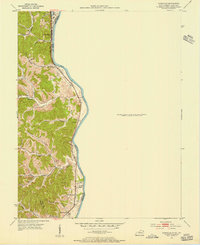
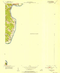 1953 Prichard1954 Print · USGSThe Big Sandy River corridor comes into focus in the early 1950s as a vital transportation link between Kentucky and West Virginia. Genealogists and rail historians can trace the paths of the Norfolk and Western railroad and locate local landmarks like Buchanan Chapel and Catalpa.2 unique versions available
 - 1953 Map of Louisa, 1955 Print
 1953 Louisa1955 Print · USGSLawrence County at the mid-century shows a landscape shaped by the confluence of the Big Sandy River and the Tug Fork. Genealogists can trace family names through numerous burial sites and rural churches like Elizabeth Jarrell Ch, Chapman Ch, and the Preece Cem.
 - 1953 Map of Catlettsburg, 1955 Print
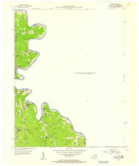
 1953 Catlettsburg1955 Print · USGSThe industrial riverfront of northeastern Kentucky is captured here just after the war, where the Ohio and Big Sandy rivers converge. Researchers can trace the mid-century footprint of Catlettsburg and Ashland alongside landmarks like England Hill Sch and Lock No 29.
 - 1953 Map of Fallsburg, 1955 Print
 1953 Fallsburg1955 Print · USGSLawrence County, Kentucky, is shown in the early fifties as a landscape defined by its deep hollows and creek-side settlements. Genealogists can locate family landmarks like Garret Chapel, Dennis Sch, and the scattered communities of Yatesville and Five Forks.2 unique versions available
 - 1953 Map of Burnaugh, 1956 Print
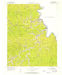
 1953 Burnaugh1956 Print · USGSBoyd County's riverfront and hill country are captured here in the early fifties, following the Big Sandy River and its rail corridor. Genealogists can locate family landmarks like Clarkson Cem, Hall Cem, and the community of Kavanaugh.
 - 1954 Map of Kermit, 1955 Print
 1954 Kermit1955 Print · USGSThe borderlands of the Tug Fork are captured in the mid-fifties, showing a landscape defined by gas extraction and isolated mountain hollows. Genealogists can trace family landmarks and rural institutions like Marcum Cem, Farley Ch, and the Head of Emily Creek Sch.
 - 1954 Map of Webb, 1955 Print
 1954 Webb1955 Print · USGSThe Tug Fork borderlands in the mid-fifties reveal a landscape of active energy extraction and tight-knit hollow settlements. Genealogists can trace family footprints through sites like Salmons Cem, Baker Gap Sch, and the community at Hode.
 - 1954 Map of Milo, 1955 Print
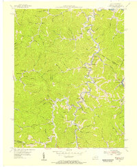 1954 Milo1955 Print · USGSIn the mid-fifties, the rugged hollows along the Tug Fork were home to a dense network of mountain schools and churches. Genealogists can locate the Stidham PO, the Old Friendship Ch, and the isolated Camp Gideon Childrens Home.4 unique versions available
 - 1957 Map of Catlettsburg, 1958 Print
 1957 Catlettsburg1958 Print · USGSThe tri-state river junction comes alive in the late fifties, showing the industrial heart of the OHIO RIVER valley. Genealogists and historians can trace family roots through the England Hill Sch, Williams Cem, and the historic streets of Kenova.2 unique versions available
 - 1957 Map of Huntington, 1959 Print
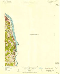
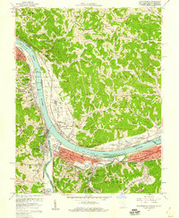
 1957 Huntington1959 Print · USGSThe industrial and academic heart of the Tri-State area comes alive in this late 1950s survey of the Ohio River valley. Researchers can trace the sprawling grounds of Marshall College, locate family plots in Spring Hill Cemetery, or follow the busy tracks of the Baltimore and Ohio railroad.
 - 1957 Map of Winslow, 1959 Print
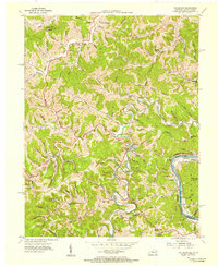
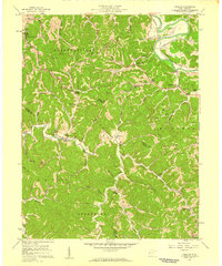 1957 Winslow1959 Print · USGSThe hills of Cabell and Wayne counties are captured here in the mid-fifties, showing a landscape of winding creek hollows and tight-knit rural communities. Researchers can locate family landmarks like the Baylous Cemetery, Davis Chapel, and the old McComas School.2 unique versions available
 - 1957 Map of Lavalette, 1959 Print
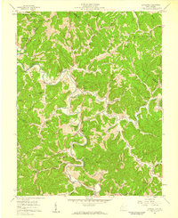 1957 Lavalette1959 Print · USGSWayne County's winding hollows come alive in the late fifties as rail lines and creekside settlements define the valley landscape. Researchers can pinpoint specific family landmarks and local institutions like Florence Memorial Ch, Mays Cem, and Dickson Falls.2 unique versions available
 - 1957 Map of Burnaugh, 1959 Print
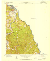
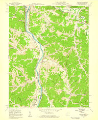 1957 Burnaugh1959 Print · USGSThe tri-state border region along the Big Sandy River comes alive in the late fifties, showing the convergence of rail, river, and mountain life. Trace family history through dozens of landmarks like Cyrus Chapel, Durbin Sch, and the U S Veterans Hospital.2 unique versions available
 - 1957 Map of Huntington, 1966 Print
 1957 Huntington1966 Print · USGSThe industrial heart of the Ohio River valley is captured here in the mid-sixties, showing the growth of Huntington and Ashland. Researchers can trace the extensive rail networks of the Chesapeake and Ohio RR and locate sites like the Chief Cornstalk Hunting Ground.3 unique versions available
 - 1957 Map of Jenkins, 1974 Print
 1957 Jenkins1974 Print · USGSThe Cumberland Plateau in the mid-twentieth century reveals a complex landscape of winding river valleys and deep-seated industry. Genealogists and historians can trace the development of Hazard, Jenkins, and Pikeville alongside extensive Numerous Oil and Gas Fields and the routes of the Chesapeake & Ohio Railway.
End of results
Showing maps 1-15 of 15
Top cities of Wayne County
Frequently asked questions
- What are the different types of historical maps available for Wayne County?
- What is the oldest map of Wayne County?
- Where can I purchase historical maps of Wayne County for my home or office?
- Where can I download high-res historical maps of Wayne County?
- Are there historical topographic maps available for Wayne County?
- Is there historical aerial imagery available for Wayne County?
- Where are historical maps of Wayne County sourced from?