1930s Maps of Wayne County, West Virginia
Explore 2 historic maps of Wayne County from the 1930s. These maps offer a rare glimpse into what life looked like during the 1930s — showing old roads, neighborhoods, homes, and landmarks that have changed or disappeared over time.
Whether you're researching your family's past, planning a metal detecting trip, or studying how Wayne County's landscape evolved across the 1930s, these high-resolution maps are a powerful tool for exploring the history of this region.
- Focus on a specific era: All maps on this page are from the 1930s, giving you a focused view of this time period.
- See what’s changed: Compare century-old streets, trails, and buildings to today's modern landscape using overlays and satellite layers.
- Research with precision: Use these maps for genealogy, historical research, land use analysis, or educational projects.
- View, download, or print: Maps are fully viewable online in high resolution, and can be downloaded or printed for your own records.
Start exploring Wayne County's history through authentic maps from the 1930s. This is your window into the past.
Wayne County, WV maps
(2)- 1931 Map of Wayne, 1956 Print
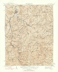 1931 Wayne1956 Print · USGSThe West Virginia hills near the Kentucky border are shown here in the early 1930s, centered on the Wayne county seat. Researchers can find numerous country schools and small rail stops along the Norfolk and Western Ry, including Genoa, Radnor, and the Quaker PO.
 - 1939 Map of Louisa
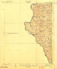 1939 Louisa1939 Print · USGSThe borderlands of West Virginia and Kentucky are captured here in the late thirties, centered on the river junctions. Researchers can trace family ties at small rural sites like Double Cabin Sch, Elijah Ch, and the settlement of Fort Gay.3 unique versions available
End of results
Showing maps 1-2 of 2
Top cities of Wayne County
Frequently asked questions
- What are the different types of historical maps available for Wayne County?
- What is the oldest map of Wayne County?
- Where can I purchase historical maps of Wayne County for my home or office?
- Where can I download high-res historical maps of Wayne County?
- Are there historical topographic maps available for Wayne County?
- Is there historical aerial imagery available for Wayne County?
- Where are historical maps of Wayne County sourced from?