1990s Maps of Wayne County, West Virginia
Explore 4 historic maps of Wayne County from the 1990s. These maps offer a rare glimpse into what life looked like during the 1990s — showing old roads, neighborhoods, homes, and landmarks that have changed or disappeared over time.
Whether you're researching your family's past, planning a metal detecting trip, or studying how Wayne County's landscape evolved across the 1990s, these high-resolution maps are a powerful tool for exploring the history of this region.
- Focus on a specific era: All maps on this page are from the 1990s, giving you a focused view of this time period.
- See what’s changed: Compare century-old streets, trails, and buildings to today's modern landscape using overlays and satellite layers.
- Research with precision: Use these maps for genealogy, historical research, land use analysis, or educational projects.
- View, download, or print: Maps are fully viewable online in high resolution, and can be downloaded or printed for your own records.
Start exploring Wayne County's history through authentic maps from the 1990s. This is your window into the past.
Wayne County, WV maps
(4)- 1992 Map of Milo
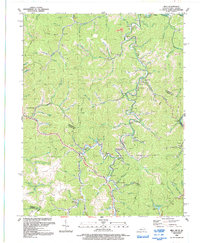 1992 Milo1992 Print · USGSMartin County and the winding Tug Fork are seen here in the early nineties, showing a landscape shaped by coal and gas. Genealogists can trace family names at Stidham, Peach Orchard, and New Friendship Ch.
 - 1992 Map of Kermit
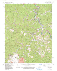 1992 Kermit1992 Print · USGSCoal and rail define this border region along the Tug Fork in the nineties. Researchers can trace the industrial footprint of the Strip Mine and Norfolk and Western railway alongside local landmarks like Warfield Sch and Gospel Light Ch.
 - 1996 Map of Wilsondale, 2003 Print
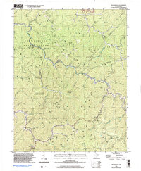 1996 Wilsondale2003 Print · USGSThe West Virginia hill country at the borders of Wayne and Mingo counties is captured here in the late twentieth century. Researchers can locate numerous family-named landmarks and burial sites like Perry Ridge Cem and the Lower Turkey Ch Sch along Twelvepole Creek.
 - 1997 Map of Trace, 2003 Print
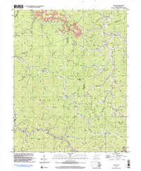 1997 Trace2003 Print · USGSThe Mingo and Logan county borders are documented here in the late nineties, showing a landscape defined by gas extraction and deep mountain hollows. Researchers can trace historic family landmarks and community sites like Hugh Dingess Sch, Elizabeth Ch, and Mt Mariah Ch Cem.
End of results
Showing maps 1-4 of 4
Top cities of Wayne County
Frequently asked questions
- What are the different types of historical maps available for Wayne County?
- What is the oldest map of Wayne County?
- Where can I purchase historical maps of Wayne County for my home or office?
- Where can I download high-res historical maps of Wayne County?
- Are there historical topographic maps available for Wayne County?
- Is there historical aerial imagery available for Wayne County?
- Where are historical maps of Wayne County sourced from?