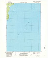
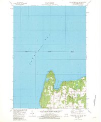
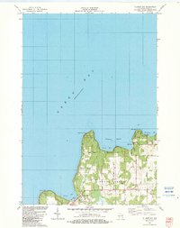
1980s Maps of Door County, Wisconsin
Explore 26 historic maps of Door County from the 1980s. These maps offer a rare glimpse into what life looked like during the 1980s — showing old roads, neighborhoods, homes, and landmarks that have changed or disappeared over time.
Whether you're researching your family's past, planning a metal detecting trip, or studying how Door County's landscape evolved across the 1980s, these high-resolution maps are a powerful tool for exploring the history of this region.
- Focus on a specific era: All maps on this page are from the 1980s, giving you a focused view of this time period.
- See what’s changed: Compare century-old streets, trails, and buildings to today's modern landscape using overlays and satellite layers.
- Research with precision: Use these maps for genealogy, historical research, land use analysis, or educational projects.
- View, download, or print: Maps are fully viewable online in high resolution, and can be downloaded or printed for your own records.
Start exploring Door County's history through authentic maps from the 1980s. This is your window into the past.
Door County, WI maps
(26)- 1981 Map of Sturgeon Bay West
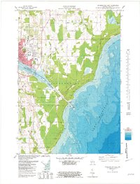
 1981 Sturgeon Bay West1981 Print · USGSThe Door Peninsula's rugged coast and maritime corridors are captured here in the early eighties. Genealogists and historians can trace family-named sites like Schulties Cem, the old Ahnapee and Western rail line, and Hainesville.
 - 1981 Map of Institute
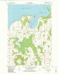
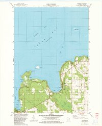
 1981 Institute1981 Print · USGSDoor County's rural heartland and Green Bay shoreline are frozen in time during the early eighties. Genealogists and local historians can trace family land via red field lines and locate community centers like Institute, St Johns Ch, and the State Agricultural Experimental Station.
 - 1981 Map of Idlewild
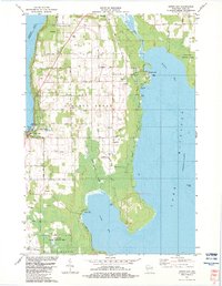
 1981 Idlewild1981 Print · USGSThe Door County coast in the early eighties shows a landscape shaped by both recreation and industry between the bays. Researchers can trace the layout of Potawatomi State Park, several active Quarry sites, and the quiet settlement at Idlewild.
 - 1981 Map of Sturgeon Bay East
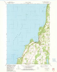
 1981 Sturgeon Bay East1981 Print · USGSThe Door County coast comes alive in the early eighties as the city of Sturgeon Bay expands toward Lake Michigan. Genealogy and local-history researchers can locate the St Joseph Cem, the Drive-in Theater, and the U S Coast Guard Station.2 unique versions available
 - 1981 Map of Marinette, 1982 Print
 1981 Marinette1982 Print · USGSThe Menominee River valley and Door County peninsula are captured here in the early 1980s, showcasing the region's timber and maritime foundations. Researchers can trace historic shorelines from Fish Creek to Deathdoor Bluff or locate inland landmarks like Lake Noquebay and Kangaroo Lake.
 - 1982 Map of Jacksonport
 1982 Jacksonport1982 Print · USGSThe Door County coastline near Jacksonport comes to life in the early 1980s, revealing a landscape of lakefront parks and rural parishes. Genealogists and historians can trace family sites at Whitefish Bay Cem or explore the geography of Clark Lake and Whitefish Dunes State Park.
 - 1982 Map of Washington Island SE
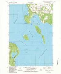
 1982 Washington Island SE1982 Print · USGSThe southeastern coast of Washington Island in the early eighties shows a landscape of coastal wetlands and protected islands. Researchers can trace the layout of Eastside County Park and the rugged offshore terrain of Fisherman Shoal and Hog Island.2 unique versions available
 - 1982 Map of Green Island
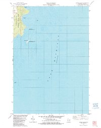
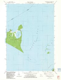
 1982 Green Island1982 Print · USGSThe waters of Green Bay meet at the interstate boundary in the early 1980s, documenting a remote maritime landscape. Researchers can examine the detailed topography of Green Island and its navigational Light at the junction of three counties.
 - 1982 Map of Washington Island NW
 1982 Washington Island NW1982 Print · USGSWashington Island's northwestern shores in the early eighties show a landscape of maritime navigation and island community life. Genealogists and local historians can locate the Township Cem, several island churches, and landmarks like the Lookout Tower and Boyer Bluff.2 unique versions available
 - 1982 Map of Jacksonport SW
 1982 Jacksonport SW1982 Print · USGSThe Door Peninsula meets the deep waters of Lake Michigan in the early eighties. Researchers can trace the shoreline drainage of Shivering Sands Creek and the township boundaries of Sevastopol.
 - 1982 Map of Baileys Harbor West, 1983 Print
 1982 Baileys Harbor West1983 Print · USGSThe Door County peninsula in the early eighties shows a landscape of wetlands and thriving local communities. Genealogists and researchers can trace family lands along Juddville Road, locate Zion Ch, or explore the shores of Kangaroo Lake.
 - 1982 Map of Ellison Bay, 1983 Print
 1982 Ellison Bay1983 Print · USGSDoor County's northern tip is captured in the early eighties, documenting the maritime communities and limestone bluffs of the peninsula. Researchers can trace the layout of Gills Rock and Ellison Bay or locate landmarks like Bethel Ch and the Ferry landing.
 - 1982 Map of Washington Island NE, 1983 Print
 1982 Washington Island NE1983 Print · USGSThe maritime frontier of Door County and Delta County is captured here in the early 1980s, documenting the remote outposts of the Green Bay entrance. Trace family roots at the Cem in Fairbanks or locate the historic Pottawatomie Light on Rock Island.2 unique versions available
 - 1982 Map of Baileys Harbor East, 1983 Print
 1982 Baileys Harbor East1983 Print · USGSThe Door County coast in the early eighties featured a quiet landscape of maritime navigation and inland wetlands. You can trace the shoreline from Cana Island to Baileys Harbor, locating old Gravel Pits and public lands like Anclam Park.
 - 1982 Map of Little Sturgeon SW, 1983 Print
 1982 Little Sturgeon SW1983 Print · USGSThe Door County shoreline of Green Bay is captured here in the early eighties as rural townships began to formalize their coastal recreation. Trace family heritage at the White Star Cem or follow old thoroughfares like Lovers Lane and Red River.
 - 1982 Map of Washington Island SW, 1983 Print
 1982 Washington Island SW1983 Print · USGSDoor County's rugged island chain is documented here in the early 1980s, centered on the maritime gateway of Detroit Harbor. Researchers can trace the coastal landmarks of the era, from the U S Coast Guard Station on Plum Island to the quiet shores of Europe Lake.2 unique versions available
 - 1982 Map of Spider Island, 1983 Print
 1982 Spider Island1983 Print · USGSThe Door Peninsula shoreline near Liberty Grove is captured here in the early eighties, highlighting a transition toward conservation. Researchers can trace the boundaries of Newport State Park and locate offshore landmarks like Spider Island and Europe Bay.2 unique versions available
 - 1982 Map of Little Sturgeon, 1983 Print
 1982 Little Sturgeon1983 Print · USGSDoor County's southern peninsula comes into focus in the early eighties, showcasing a mix of wetland conservation and coastal settlement. Genealogists and historians can locate family landmarks like the Stevenson Cem, St Joseph Ch, and Tornado Memorial County Park.
 - 1982 Map of Algoma NE, 1983 Print
 1982 Algoma NE1983 Print · USGSThe Door County shoreline at Lake Michigan shows a quiet coastal landscape in the early eighties. Researchers can locate family landmarks like Mt Lookout, the historic Claybanks Cem, and the small settlement of Salona.
 - 1982 Map of Forestville, 1983 Print
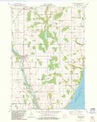 1982 Forestville1983 Print · USGSIn the early 1980s, the Door and Kewaunee border was a quiet landscape of dairy country and river bends. Genealogists can trace family names and local landmarks through sites like St Marys Ch, Tanum Ch Cem, and the village of Forestville.
 - 1982 Map of Egg Harbor, 1983 Print
 1982 Egg Harbor1983 Print · USGSDoor County's shoreline in the early 1980s showcases a transition from rural farmland to a coastal getaway. Genealogists can trace family names at Egg Harbor Cem and Juddville Cem or locate old homesteads near Horseshoe Bay.
 - 1982 Map of Sister Bay, 1983 Print
 1982 Sister Bay1983 Print · USGSThe northern Door Peninsula comes into focus in the early eighties as a hub of conservation and coastal life. Researchers can trace local heritage at Ellison Bay Cem or explore the wild margins of the Mink River and Newport State Park.
 - 1982 Map of Ephraim, 1983 Print
 1982 Ephraim1983 Print · USGSDoor County's shoreline thrives in the early eighties as a mix of maritime heritage and vacation life. Researchers can locate historic sites like Blossomburg Cem, the Pioneer Sch, and the Light on Horseshoe Island.
 - 1982 Map of Chambers Island, 1983 Print
 1982 Chambers Island1983 Print · USGSChambers Island and its surrounding waters in the early eighties show a landscape of secluded retreats and maritime markers. Researchers can trace the layout of the Diocese Retreat, find the northern Lighthouse, and explore the cluster of the Strawberry Islands.2 unique versions available
 - 1984 Map of Sturgeon Bay, 1985 Print
 1984 Sturgeon Bay1985 Print · USGSDoor Peninsula and the Kewaunee coast are documented here in the mid-eighties, showing the deep-water harbor at Sturgeon Bay and the rural agricultural interior. Genealogists can trace family roots through crossroads towns like Kolberg, Duvall, and Sugar Bush.2 unique versions available
Showing maps 1-25 of 26
Top cities of Door County
- Sturgeon Bay historical maps
- Brussels historical maps
- Baileys Harbor historical maps
- Sister Bay historical maps
- Jacksonport historical maps
- Washington historical maps
See more
Frequently asked questions
- What are the different types of historical maps available for Door County?
- What is the oldest map of Door County?
- Where can I purchase historical maps of Door County for my home or office?
- Where can I download high-res historical maps of Door County?
- Are there historical topographic maps available for Door County?
- Is there historical aerial imagery available for Door County?
- Where are historical maps of Door County sourced from?