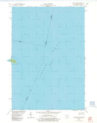
1982 Map of Green Island
USGS Topo · Published 1982About this map
Green Island sits within the expanse of Green Bay in this maritime survey, which documents the waters at the tri-county intersection of Menominee, Marinette, and Door counties. The small island is the central topographical feature, marked by a navigational Light on its eastern shore. This 1982 edition captures the hydrographic state of the bay, showing an indefinite boundary and the complex underwater contours that defined these shipping lanes in the early 1980s. The map serves as a record of the Michigan-Wisconsin border where it crosses open water, providing essential detail for those studying the maritime history and political geography of the Great Lakes.
Find a feature on this map
7 named features on this map. Tap any name to fly to it.
Don’t see what you’re looking for? This feature index may not catch every label — zoom into the map to look around manually.
Map Details
Editions of this 1982 Green Island Map
This is the sole edition of this map. No revisions or reprints were ever made.
Other maps of this area

1939 · Marinette
USGS Topo · 1:48,000

1954 · Escanaba
USGS Topo · 1:250,000

1954 · Manitowoc
USGS Topo · 1:250,000

1957 · Escanaba
USGS Topo · 1:250,000

1958 · Escanaba
USGS Topo · 1:250,000

1958 · Manitowoc
USGS Topo · 1:250,000

1960 · Sturgeon Bay
USGS Topo · 1:62,500

1961 · Little Sturgeon
USGS Topo · 1:62,500

1961 · Chambers Island
USGS Topo · 1:62,500
1963 · Birch Creek
USGS Topo · 1:24,000