Old Maps of Clifton, Wisconsin for Genealogy
Trace your family roots with 17 historic maps of Clifton. These high-res maps reveal old neighborhoods, homesites, landmarks, and streets — helping you uncover where your ancestors lived and how the area evolved over time.
- Explore historic neighborhoods: Identify where your relatives may have lived in the 1800s or 1900s.
- Compare maps over time: Trace the changes in streets, buildings, and landmarks for multi-generational research.
- Perfect for genealogy & ancestry research: Used by family historians and researchers to map out lineage and migration.
These maps are an incredible resource for exploring your personal connection to Clifton's past.
Clifton, WI maps
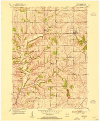
(17)- 1900 Map of Lancaster
 1900 Lancaster1900 Print · USGSGrant County and the Mississippi River bluffs are captured at the close of the nineteenth century, showing a landscape of river towns and ridge-top farms. Researchers can trace the early rail corridors and vanished river landings from Cassville and Potosi to the county seat at Lancaster.
 - 1902 Map of Mineral Point
 1902 Mineral Point1902 Print · USGSSouthwest Wisconsin and Northern Illinois are mapped here at the height of the regional mining era. Genealogists and historians can trace the rail lines of the Illinois Central to vanished junctions and local landmarks like Meekers Grove, Calamine, and Elk Grove.4 unique versions available
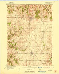
 - 1904 Map of Lancaster, 1953 Print
 1904 Lancaster1953 Print · USGSSouthwest Wisconsin and its neighboring river lands are shown at the turn of the century as railroads began to dominate the ridge tops. Researchers can trace the development of the river-and-rail economy through sites like Spechts Ferry, Sinsinawa Mound, and Lancaster.
 - 1908 Map of Lancaster
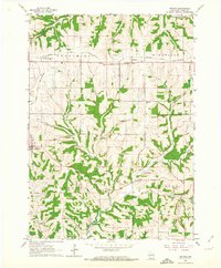
 1908 Lancaster1908 Print · USGSGrant County and the Mississippi River border appear in the first decade of the twentieth century, when river crossings and new rail lines defined local commerce. Researchers can trace the landings at Spechts Ferry and Mc Cartney or locate early settlements like British Hollow and Beetown.5 unique versions available
 - 1952 Map of Rewey, 1954 Print
 1952 Rewey1954 Print · USGSRewey and the surrounding dairy country of Iowa, Grant, and Lafayette counties are shown here in the early fifties during a period of transition. Genealogists can locate several family-named burial sites like McReynolds Cem and rural schoolhouses including Hazel Dell Sch and Sunny Dale Sch.3 unique versions available
 - 1952 Map of Montfort, 1954 Print
 1952 Montfort1954 Print · USGSThe dairy lands and driftless ridges of Grant and Iowa Counties are documented here in the early fifties. Genealogists can locate numerous rural schoolhouses and family burial sites such as Rock Church Cem, Oak Grove Sch, and the Mifflin Mine works.2 unique versions available
 - 1959 Map of Dubuque, 1982 Print
 1959 Dubuque1982 Print · USGSThe Tri-State region comes alive in the mid-twentieth century as a hub of river commerce and rail transit. Genealogists and historians can trace the paths of the Illinois Central Gulf through Dubuque or locate the Savanna Ordnance Depot and Lock and Dam No 11.
 - 1961 Map of Dubuque
 1961 Dubuque1961 Print · USGSThe Tri-State region's river-and-rail landscape is captured here during the early sixties, showing the convergence of Iowa, Illinois, and Wisconsin. Trace mid-century rail lines like the Chicago Great Western Ry and explore sites like the Savanna Ordnance Depot and Backbone State Park.
 - 1962 Map of Dubuque
 1962 Dubuque1962 Print · USGSThe Tri-State region's river-and-rail economy is captured here in the early sixties, centered on the Mississippi River bluffs. Genealogists and historians can locate Numerous lead and zinc mines, the New Melleray Abbey Monastery, and rural hubs like Saint Olaf.2 unique versions available
 - 1962 Map of Stitzer, 1964 Print
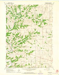
 1962 Stitzer1964 Print · USGSGrant County’s dissected uplands are shown in the early sixties as a network of farmsteads and railroad towns. Genealogists can locate family landmarks like Blue Sch and Ebenezer Cem, or trace the old rail stops at Preston and Lancaster Junction.
 - 1962 Map of Ellenboro, 1964 Print
 1962 Ellenboro1964 Print · USGSGrant County's rural landscape is captured here in the early sixties, showing the intricate network of ridge-top farms and valley settlements. Genealogists can trace family footprints across several burial sites and rural institutions, including Whig Cem, Union Sch, and the riverside community of Ellenboro.2 unique versions available
 - 1976 Map of Dubuque
 1976 Dubuque1976 Print · USGSThe tri-state borderlands of Iowa, Wisconsin, and Illinois come alive during the mid-seventies, showing a region built on river commerce and mining. Genealogists and historians can trace the paths of the Illinois Central railroad or locate heritage sites like the New Melleray Abbey Monastery and Backbone State Park.
 - 1984 Map of Dubuque North, 1985 Print
 1984 Dubuque North1985 Print · USGSThis Tri-State region was a hub of Midwestern mining and river commerce in the mid-eighties. Researchers can trace the legacy of the Lead District through specific sites like Annie Mine or locate early civic centers such as First Capitol State Park.2 unique versions available
 - 2022 Map of Rewey, 2022 Print
 2022 Rewey2022 Print · USGSThe rural driftless area of Southwest Wisconsin is documented here in the early twenty-first century, showing the enduring boundaries of Grant, Iowa, and Lafayette counties. Researchers can trace family history at Nip and Tuck Cem or locate old farmsteads near Rewey and Little Mound.
 - 2022 Map of Ellenboro, 2022 Print
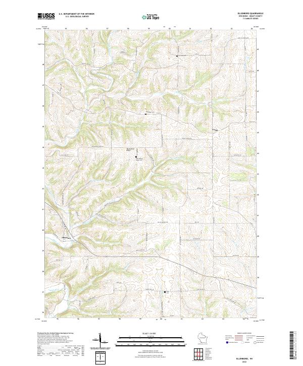 2022 Ellenboro2022 Print · USGSGrant County's river valleys and highland ridges are captured here in the early twenty-first century as the traditional agricultural layout persists. Local historians can trace family roots through sites like Buckwheat Ridge Cem, Whig Cem, and the quiet settlement of Ellenboro.
 - 2022 Map of Montfort, 2022 Print
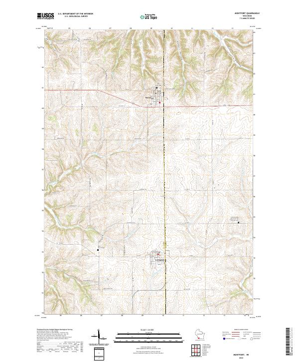 2022 Montfort2022 Print · USGSThe ridge-top communities of Montfort and Livingston are shown in the 2020s amidst the complex valley systems of the Driftless Area. Researchers can locate family landmarks like Hill Crest Cem or the distinctively named Little German Church On Top Of The Hill Cem.
 - 2022 Map of Stitzer, 2022 Print
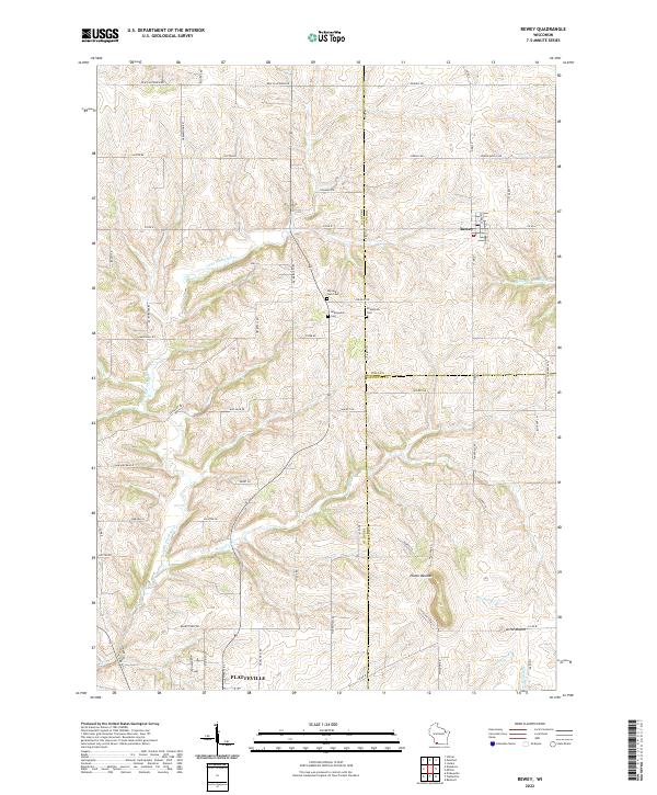
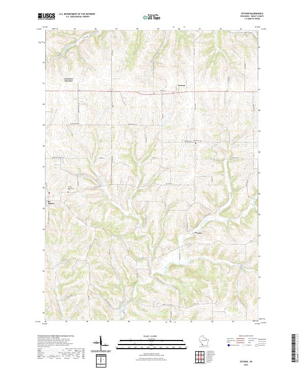 2022 Stitzer2022 Print · USGSGrant County is captured in this recent survey, showing a landscape defined by the winding Platte River and traditional farm-to-market roads. Researchers can locate family roots at the Stitzer Methodist Cem or trace the early paths of Military Rd near Annaton.
End of results
Showing maps 1-17 of 17
Top cities near Clifton
- Platteville historical maps
- Lancaster historical maps
- Boscobel historical maps
- Fennimore historical maps
- Belmont historical maps
- Highland historical maps
See more
Top neighborhoods of Clifton
Frequently asked questions
- What are the different types of historical maps available for Clifton?
- What is the oldest map of Clifton?
- Where can I purchase historical maps of Clifton for my home or office?
- Where can I download high-res historical maps of Clifton?
- Are there historical topographic maps available for Clifton?
- Is there historical aerial imagery available for Clifton?
- Where are historical maps of Clifton sourced from?