1940s Maps of Jackson County, Wisconsin
Explore 6 historic maps of Jackson County from the 1940s. These maps offer a rare glimpse into what life looked like during the 1940s — showing old roads, neighborhoods, homes, and landmarks that have changed or disappeared over time.
Whether you're researching your family's past, planning a metal detecting trip, or studying how Jackson County's landscape evolved across the 1940s, these high-resolution maps are a powerful tool for exploring the history of this region.
- Focus on a specific era: All maps on this page are from the 1940s, giving you a focused view of this time period.
- See what’s changed: Compare century-old streets, trails, and buildings to today's modern landscape using overlays and satellite layers.
- Research with precision: Use these maps for genealogy, historical research, land use analysis, or educational projects.
- View, download, or print: Maps are fully viewable online in high resolution, and can be downloaded or printed for your own records.
Start exploring Jackson County's history through authentic maps from the 1940s. This is your window into the past.
Jackson County, WI maps
(6)- 1940 Map of Osseo
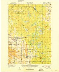
 1940 Osseo1940 Print · USGSOsseo and Augusta anchored this river-carved landscape of west-central Wisconsin in the years surrounding the Great Depression. Researchers can trace the heritage of rural neighborhoods through several dozen district schools, including Troubled Waters Sch, Yule Sch, and Churchview Sch.
 - 1947 Map of Millston, 1963 Print
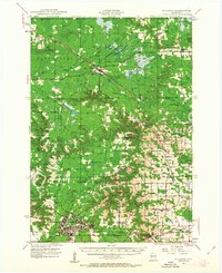 1947 Millston1963 Print · USGSMid-century Jackson and Monroe counties are captured here just after the war, showing the expansion of military and rail infrastructure. Genealogists can locate family sites near North Tomah or trace rural landmarks like Tarr Valley Sch and La Grange Cem.4 unique versions available
 - 1948 Map of Fairchild, 1966 Print
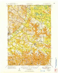
 1948 Fairchild1966 Print · USGSWisconsin's West-Central borderlands emerge in this post-war study of the rail-centered towns of Fairchild and Humbird. You can trace the legacy of rural education and industry through numerous landmarks like Blackberry Sch, Wildcat Mound, and the Chicago and North Western rail line.2 unique versions available
 - 1949 Map of Millston
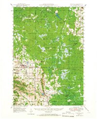
 1949 Millston1949 Print · USGSWisconsin's central cranberry and timber country is captured here in the late 1940s as the regional rail network anchored rural life. Researchers can trace the layout of the Camp McCoy Military Reservation or locate family sites near Millston, Tunnel City, and several rural schoolhouses like White School.
 - 1949 Map of Melrose
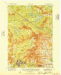
 1949 Melrose1949 Print · USGSJackson and Monroe Counties appear here in the late 1940s as a thriving patchwork of valley farms and small rural hubs. Genealogists can locate dozens of family-named landmarks and institutions, from the Little Norway Ch and Irving Cem to the Jenkins Valley Sch.
 - 1949 Map of Fairchild
 1949 Fairchild1949 Print · USGSThe rural borderlands of Eau Claire, Clark, and Jackson Counties appear here in the late 1940s, centered on the towns of Fairchild and Humbird. Researchers can locate numerous one-room schools like Lone Pine Sch, trace the Chicago and North Western rail line, or find local family sites at Cleveland Cem.
End of results
Showing maps 1-6 of 6
Top cities of Jackson County
- Black River Falls historical maps
- Brockway historical maps
- Irving historical maps
- Northfield historical maps
- Merrillan historical maps
- Melrose historical maps
See more
Frequently asked questions
- What are the different types of historical maps available for Jackson County?
- What is the oldest map of Jackson County?
- Where can I purchase historical maps of Jackson County for my home or office?
- Where can I download high-res historical maps of Jackson County?
- Are there historical topographic maps available for Jackson County?
- Is there historical aerial imagery available for Jackson County?
- Where are historical maps of Jackson County sourced from?