Old Maps of Jackson County, Wisconsin for Genealogy
Trace your family roots with 88 historic maps of Jackson County. These high-res maps reveal old neighborhoods, homesites, landmarks, and streets — helping you uncover where your ancestors lived and how the area evolved over time.
- Explore historic neighborhoods: Identify where your relatives may have lived in the 1800s or 1900s.
- Compare maps over time: Trace the changes in streets, buildings, and landmarks for multi-generational research.
- Perfect for genealogy & ancestry research: Used by family historians and researchers to map out lineage and migration.
These maps are an incredible resource for exploring your personal connection to Jackson County's past.
Jackson County, WI maps
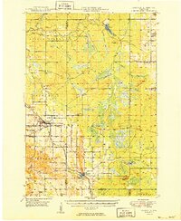
(88)- 1924 Map of Black River Falls, 1963 Print
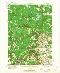
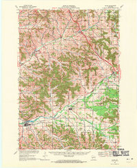
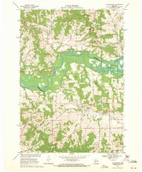
 1924 Black River Falls1963 Print · USGSBlack River Falls and the surrounding central Wisconsin hills are captured in the mid-1920s during a period of established rail transport and rural education. Genealogists can trace a dense network of country schools and settlements including Winnebago Mission, Charter Oak Mill, and Vaudreuil.2 unique versions available
 - 1926 Map of Black River Falls
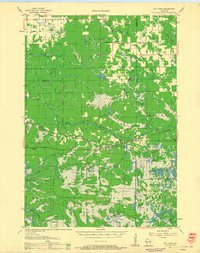
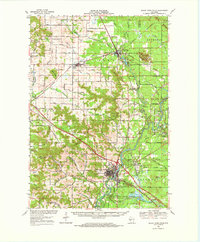
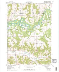
 1926 Black River Falls1926 Print · USGSJackson County is shown during a period of steady rural growth in the 1920s, centered on the bustling river town of Black River Falls. Local historians can trace dozens of rural schoolhouses and vanished sidings like Vaudreuil and Sheppard along the rail lines.
 - 1926 Map of North Bend, 1965 Print
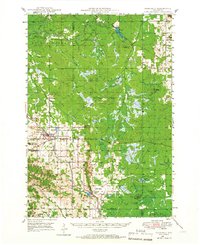
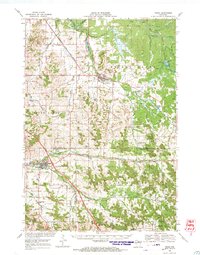
 1926 North Bend1965 Print · USGSJackson and La Crosse counties are shown here in the mid-twenties, when the Black River valley was dotted with small family farms and dozens of rural school districts. Genealogists can trace ancestral locations near Stevenstown, Mindoro, and Upper Beaver Creek Ch.
 - 1927 Map of Blair
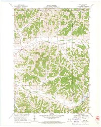
 1927 Blair1927 Print · USGSIn the 1920s, the coulee country of Trempealeau and Jackson Counties was a landscape of tightly-knit valley settlements and rural schools. Genealogists can trace family footprints through numerous local landmarks like Schermerhorn School, Pigeon Falls, and Fly Creek School.2 unique versions available
 - 1928 Map of Melrose
 1928 Melrose1928 Print · USGSThe Black River valley in the late nineteen-twenties was a landscape of ridge-top farms and valley-floor schools. Genealogists can trace family footprints through numerous rural landmarks like Irving School No 6, Sand Creek Cem, and Wadels Hill.
 - 1929 Map of North Bend
 1929 North Bend1929 Print · USGSWisconsin's coulee country comes alive in this late 1920s survey of the tri-county borderlands along the Black River. Genealogists and local historians can trace family-named landmarks and rural hubs like Beachs Corners, Burr Oak, and the many one-room schoolhouses like Lone Star Sch.2 unique versions available
 - 1935 Map of Osseo
 1935 Osseo1935 Print · USGSOsseo and Augusta were busy railway and river hubs in the mid-1930s, where the rural landscape was tied together by dozens of local schools and the Chicago and Northwestern. Genealogists can trace family footprints at Bear Grass Cem and vanished rural landmarks like Rodell Spur and Troubled Waters Sch.
 - 1940 Map of Osseo
 1940 Osseo1940 Print · USGSOsseo and Augusta anchored this river-carved landscape of west-central Wisconsin in the years surrounding the Great Depression. Researchers can trace the heritage of rural neighborhoods through several dozen district schools, including Troubled Waters Sch, Yule Sch, and Churchview Sch.
 - 1947 Map of Millston, 1963 Print
 1947 Millston1963 Print · USGSMid-century Jackson and Monroe counties are captured here just after the war, showing the expansion of military and rail infrastructure. Genealogists can locate family sites near North Tomah or trace rural landmarks like Tarr Valley Sch and La Grange Cem.4 unique versions available
 - 1948 Map of Fairchild, 1966 Print
 1948 Fairchild1966 Print · USGSWisconsin's West-Central borderlands emerge in this post-war study of the rail-centered towns of Fairchild and Humbird. You can trace the legacy of rural education and industry through numerous landmarks like Blackberry Sch, Wildcat Mound, and the Chicago and North Western rail line.2 unique versions available
 - 1949 Map of Millston
 1949 Millston1949 Print · USGSWisconsin's central cranberry and timber country is captured here in the late 1940s as the regional rail network anchored rural life. Researchers can trace the layout of the Camp McCoy Military Reservation or locate family sites near Millston, Tunnel City, and several rural schoolhouses like White School.
 - 1949 Map of Melrose
 1949 Melrose1949 Print · USGSJackson and Monroe Counties appear here in the late 1940s as a thriving patchwork of valley farms and small rural hubs. Genealogists can locate dozens of family-named landmarks and institutions, from the Little Norway Ch and Irving Cem to the Jenkins Valley Sch.
 - 1949 Map of Fairchild
 1949 Fairchild1949 Print · USGSThe rural borderlands of Eau Claire, Clark, and Jackson Counties appear here in the late 1940s, centered on the towns of Fairchild and Humbird. Researchers can locate numerous one-room schools like Lone Pine Sch, trace the Chicago and North Western rail line, or find local family sites at Cleveland Cem.
 - 1953 Map of Eau Claire, 1965 Print
 1953 Eau Claire1965 Print · USGSWest-central Wisconsin in the mid-fifties shows a landscape of river-valley industry and vast wildlife refuges during the transition from rails to modern highways. Genealogists and historians can trace the rail corridors of the Chicago and North Western or locate family-named landmarks like Decorah Mound and Chippewa Island.4 unique versions available
 - 1957 Map of City Point, 1960 Print
 1957 City Point1960 Print · USGSJackson and Clark Counties are shown here in the late fifties, dominated by the timber and cranberry industries of the Central Wisconsin Sand County. Genealogists and historians can locate rural landmarks like Audubon Sch, Martyrs Cem, and the old rail siding at Spaulding.2 unique versions available
 - 1958 Map of Eau Claire
 1958 Eau Claire1958 Print · USGSWestern Wisconsin in the late fifties shows a landscape of growing regional hubs and massive wildlife refuges. Trace the rail lines of the Chicago and North Western between Eau Claire and Marshfield, or explore the terrain around Iron Mound and Lake Wissota.
 - 1958 Map of Hatfield, 1960 Print
 1958 Hatfield1960 Print · USGSIn the late fifties, the central Wisconsin lake country was defined by its vast flowage systems and timbered mounds. Researchers can trace rural school locations like Carlyle Sch and explore old transport routes through Komensky Station or along an old railroad grade.
 - 1958 Map of Wyeville, 1960 Print
 1958 Wyeville1960 Print · USGSWisconsin's cranberry and timber country is documented here in the late fifties, centered on the rail junctions of Monroe and Juneau Counties. You can trace the rural infrastructure of the day, from the Indian Cem and St Marks Ch to the Chicago and North Western rail lines.
 - 1964 Map of Eau Claire
 1964 Eau Claire1964 Print · USGSWest-central Wisconsin in the mid-1960s was a hub of river-driven industry and expanding rail networks. Researchers can trace historic homesteads near Menomonie, follow the Soo Line RR through Marshfield, or explore the grounds of the Camp McCoy Military Reservation.
 - 1968 Map of Blair, 1971 Print
 1968 Blair1971 Print · USGSWisconsin's coulee country comes into focus in the late sixties, showing the vital rail-and-river corridor between Blair and Hixton. Researchers can locate the Amish Sch, trace the Green Bay and Western line, and find family names near French Creek Cem.2 unique versions available
 - 1968 Map of Osseo, 1971 Print
 1968 Osseo1971 Print · USGSOsseo and Augusta appear in the late sixties as vital hubs for the Chicago and North Western rail line and regional farming. Researchers can locate historic rural congregations and resting places like St Peters Ch and Thompson Valley Cem amidst a network of small dairy-country valleys.
 - 1968 Map of Black River Falls, 1971 Print
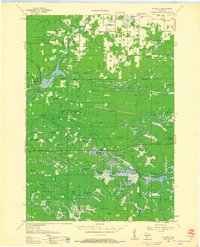
 1968 Black River Falls1971 Print · USGSThe Black River valley comes alive in this late-sixties survey, showing the busy rail junction at Merrillan and the growing county seat at Black River Falls. Genealogists and historians can trace local roots at the Winnebago Mission, Cloverdale School, and Stanford Cem.
 - 1969 Map of Hegg, 1971 Print
 1969 Hegg1971 Print · USGSWestern Wisconsin in the late sixties reveals a landscape of deep coulees and ridge-top farms centered around the community of Hegg. Local historians can trace family-named landmarks like Borreson Coulee or locate regional spiritual centers including North Beaver Creek Ch and the Pioneer Cem.2 unique versions available
 - 1969 Map of Stevenstown, 1971 Print
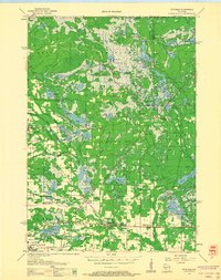
 1969 Stevenstown1971 Print · USGSThe Black River valley during the late sixties serves as a crossroads of family history and conservation in rural Wisconsin. Genealogists can trace lineage through Hardies Cemetery or Sacia Cemetery, while outdoorsmen can locate the State Game Refuge and Horseshoe Lake.2 unique versions available
 - 1969 Map of North Bend, 1971 Print
 1969 North Bend1971 Print · USGSThe Black River valley and its intricate coulees are documented here during the late sixties, spanning the border of Jackson and La Crosse counties. Genealogists can locate family-named landmarks and rural burial sites like Oxbow Cem, the historic Red School, and the German Settlement.2 unique versions available
Showing maps 1-25 of 88
Top cities of Jackson County
- Black River Falls historical maps
- Brockway historical maps
- Irving historical maps
- Northfield historical maps
- Merrillan historical maps
- Melrose historical maps
See more
Frequently asked questions
- What are the different types of historical maps available for Jackson County?
- What is the oldest map of Jackson County?
- Where can I purchase historical maps of Jackson County for my home or office?
- Where can I download high-res historical maps of Jackson County?
- Are there historical topographic maps available for Jackson County?
- Is there historical aerial imagery available for Jackson County?
- Where are historical maps of Jackson County sourced from?