Old Maps of Hill, Wisconsin for Academic Research
Study the evolution of Hill with 14 high-resolution historic maps. Whether you're teaching, researching, or modeling changes in land use, these maps provide essential visual documentation of urban, environmental, and geographic change.
- Analyze long-term change: Track patterns in development, transportation, and natural features.
- Ideal for environmental or urban studies: Support academic projects with primary historical map data.
- Use in the classroom or lab: Educators and researchers rely on these maps to bring historical context to life.
These maps are a powerful tool for teaching, research, and visualizing how Hill has changed over the decades.
Hill, WI maps
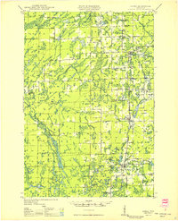
(14)- 1944 Map of Ogema
 1944 Ogema1944 Print · USGSPrice County during the early 1940s was a landscape of remote farmsteads and timber interests centered on the rail corridor. Genealogists can trace family locations through a dense network of country schools like Forest Hill Sch and Larkin Sch, or the small siding at Mackeys Spur.
 - 1945 Map of Rib Lake
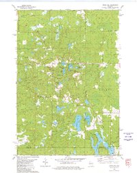
 1945 Rib Lake1945 Print · USGSNorthern Wisconsin lake country is captured here during the 1940s, showing a landscape of timber and township life. Genealogists can locate rural landmarks like Spirit Town Hall, Mission Ch, and schools like Ring Sch or Stone Lake Sch.
 - 1947 Map of Rib Lake, 1956 Print
 1947 Rib Lake1956 Print · USGSTaylor and Price Counties come into focus during the late 1940s, a period when the timber industry and small-town life shaped this north-central Wisconsin landscape. Genealogists can trace family footprints through rural landmarks like Mission Ch, Stone Lake Sch, and the village of Rib Lake.
 - 1947 Map of Ogema, 1966 Print
 1947 Ogema1966 Print · USGSPrice and Taylor Counties are captured here just after the war, showing a rural landscape defined by logging, rail, and small lakeside settlements. Genealogists can trace family roots through numerous country schools like Centerville Sch and landmarks like Mt Olive Cem or Mackeys Spur.
 - 1949 Map of Ogema
 1949 Ogema1949 Print · USGSPrice and Taylor Counties are captured here in the late 1940s, showing the Northwoods before the modern era of highway expansion. Genealogists and local historians can trace many rural schoolhouses like Centerville School, church sites at Mt Olive Cemetery, and the Soo Line rail stops.
 - 1949 Map of Rib Lake
 1949 Rib Lake1949 Print · USGSRib Lake and the surrounding Northwoods townships appear here in the late 1940s, just as the rural schoolhouse system remained a central pillar of the community. Genealogists and historians can locate numerous local landmarks like Ring Sch, the Wilderness Lookout Tower, and the Mission Ch.
 - 1953 Map of Rice Lake, 1967 Print
 1953 Rice Lake1967 Print · USGSNorthwest Wisconsin during the mid-fifties reveals a landscape defined by timber, rail, and water. Genealogists and historians can trace the development of river towns like Ladysmith and Rice Lake along the Soo Line and Chicago and North Western railroads.2 unique versions available
 - 1959 Map of Rice Lake
 1959 Rice Lake1959 Print · USGSNorthwest Wisconsin in the late fifties was a land of expanding road networks and deep-seated timber history. Genealogists and historians can trace rail lines like the Soo Line RR and Chicago St Paul Minneapolis and Omaha Ry as they link settlements from Spooner to Medford.
 - 1970 Map of Ogema, 1972 Print
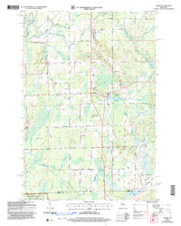
 1970 Ogema1972 Print · USGSPrice and Taylor counties come into focus in the early 1970s, centered on the millpond and rail-side settlements of the Wisconsin Northwoods. Genealogists and local historians can trace family locations along Hallstrand Road, visit Hillside Cem, or locate the old Townhall and Mackeys Spur.
 - 1979 Map of Timms Hill, 1980 Print
 1979 Timms Hill1980 Print · USGSThe Wisconsin Northwoods are captured here in the late seventies, centered on the state's highest elevation. Local historians can locate the Garden of Memory Church, trace old routes like Goetzke Road, and explore the shoreline of Spirit Lake.2 unique versions available
 - 1980 Map of Medford
 1980 Medford1980 Print · USGSNorth-central Wisconsin in the early eighties shows a landscape of dense timber and rail-linked settlements. Genealogists and historians can trace the Soo Line through towns like Medford and Westboro or locate family homesteads near Perkinstown and Athens.
 - 2005 Map of Ogema, 2006 Print
 2005 Ogema2006 Print · USGSThe settlement of Ogema and the surrounding Price County woods are captured here at the start of the twenty-first century. Genealogists and hikers can trace family-named routes like Hallstrand Road or find the Hillside Cem and Levitt Creek Cem.
 - 2022 Map of Timms Hill, 2022 Print
 2022 Timms Hill2022 Print · USGSNorthern Wisconsin's glacial landscape is documented here in the early twenty-first century, spanning the border of Price and Taylor counties. Researchers can trace the path of the Ice Age Trl past Timms Hill and locate the Garden of Memory Cem.
 - 2022 Map of Ogema, 2022 Print
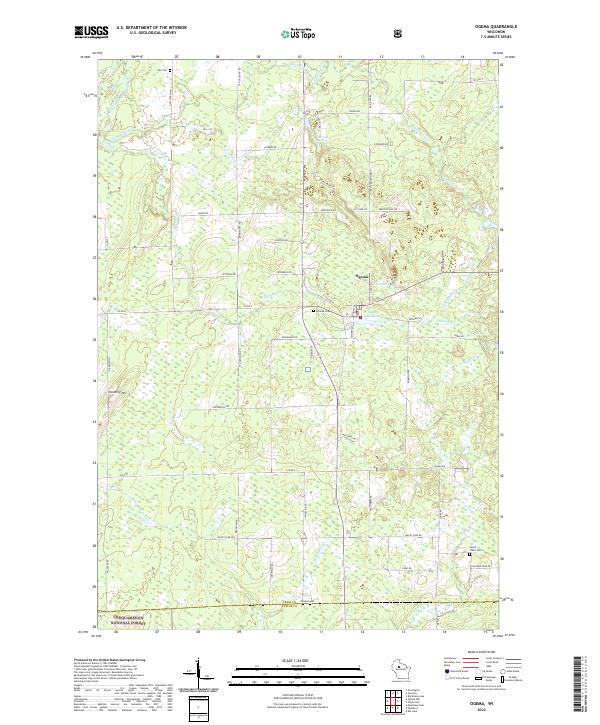 2022 Ogema2022 Print · USGSIn the heart of Price County, this 2022 survey captures the small-town character of Ogema and its surrounding timberlands. Genealogists and local historians can locate early burial sites like Hillside Cem and Will Cem, or trace the legacy of local industry at the Ogema Millpond.
End of results
Showing maps 1-14 of 14
Top cities near Hill
- Worcester historical maps
- Ogema historical maps
- Rib Lake historical maps
- Chelsea historical maps
- Westboro historical maps
- Prentice historical maps
See more
Frequently asked questions
- What are the different types of historical maps available for Hill?
- What is the oldest map of Hill?
- Where can I purchase historical maps of Hill for my home or office?
- Where can I download high-res historical maps of Hill?
- Are there historical topographic maps available for Hill?
- Is there historical aerial imagery available for Hill?
- Where are historical maps of Hill sourced from?