1950s Maps of Sawyer County, Wisconsin
Explore 6 historic maps of Sawyer County from the 1950s. These maps offer a rare glimpse into what life looked like during the 1950s — showing old roads, neighborhoods, homes, and landmarks that have changed or disappeared over time.
Whether you're researching your family's past, planning a metal detecting trip, or studying how Sawyer County's landscape evolved across the 1950s, these high-resolution maps are a powerful tool for exploring the history of this region.
- Focus on a specific era: All maps on this page are from the 1950s, giving you a focused view of this time period.
- See what’s changed: Compare century-old streets, trails, and buildings to today's modern landscape using overlays and satellite layers.
- Research with precision: Use these maps for genealogy, historical research, land use analysis, or educational projects.
- View, download, or print: Maps are fully viewable online in high resolution, and can be downloaded or printed for your own records.
Start exploring Sawyer County's history through authentic maps from the 1950s. This is your window into the past.
Sawyer County, WI maps
(6)- 1950 Map of Stone Lake
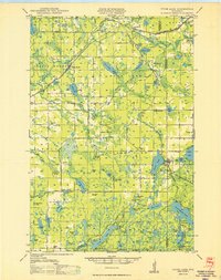 1950 Stone Lake1950 Print · USGSWashburn and Sawyer Counties are shown in the 1950s at the height of their rural rail and schoolhouse era. Researchers can trace the legacy of small communities through the Evergreen Cem, the Potato Lake Fire Tower, and local landmarks like Stinnett Sch and Mackay Valley Sch.
 - 1951 Map of Rice Lake
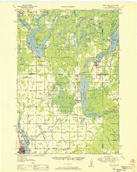 1951 Rice Lake1951 Print · USGSNorthwest Wisconsin’s lake country is captured in the early fifties, showing the transition from rail-dependent commerce to modern aviation. Researchers can trace dozens of country schoolhouses like Pioneer Sch and Lincoln Sch, or locate the Rice Lake Municipal Airport.
 - 1953 Map of Ashland, 1964 Print
 1953 Ashland1964 Print · USGSNorthern Wisconsin's lakefront and timberlands are seen here in the mid-1950s, showing the intersection of industrial rail lines and vast wilderness. Genealogists and historians can trace the Soo Line through rail towns like Mellen or locate family roots in the Apostle Islands and Bad River Indian Reservation.3 unique versions available
 - 1953 Map of Rice Lake, 1967 Print
 1953 Rice Lake1967 Print · USGSNorthwest Wisconsin during the mid-fifties reveals a landscape defined by timber, rail, and water. Genealogists and historians can trace the development of river towns like Ladysmith and Rice Lake along the Soo Line and Chicago and North Western railroads.2 unique versions available
 - 1958 Map of Ashland
 1958 Ashland1958 Print · USGSCoastal Wisconsin and the Michigan borderlands meet here in the late fifties, dominated by the timbered expanses and iron-rich ranges. Genealogists can trace family footprints in settlements like Odanah and Montreal, or locate landmarks such as the Coast Guard Station and Agricultural Experiment Station.
 - 1959 Map of Rice Lake
 1959 Rice Lake1959 Print · USGSNorthwest Wisconsin in the late fifties was a land of expanding road networks and deep-seated timber history. Genealogists and historians can trace rail lines like the Soo Line RR and Chicago St Paul Minneapolis and Omaha Ry as they link settlements from Spooner to Medford.
End of results
Showing maps 1-6 of 6
Top cities of Sawyer County
- Hayward historical maps
- Edgewater historical maps
- Weirgor historical maps
- Winter historical maps
- Ojibwa historical maps
- Radisson historical maps
See more
Frequently asked questions
- What are the different types of historical maps available for Sawyer County?
- What is the oldest map of Sawyer County?
- Where can I purchase historical maps of Sawyer County for my home or office?
- Where can I download high-res historical maps of Sawyer County?
- Are there historical topographic maps available for Sawyer County?
- Is there historical aerial imagery available for Sawyer County?
- Where are historical maps of Sawyer County sourced from?