1940s Maps of Douglas, Wyoming
Explore 4 historic maps of Douglas from the 1940s. These maps offer a rare glimpse into what life looked like during the 1940s — showing old roads, neighborhoods, homes, and landmarks that have changed or disappeared over time.
Whether you're researching your family's past, planning a metal detecting trip, or studying how Douglas's landscape evolved across the 1940s, these high-resolution maps are a powerful tool for exploring the history of this region.
- Focus on a specific era: All maps on this page are from the 1940s, giving you a focused view of this time period.
- See what’s changed: Compare century-old streets, trails, and buildings to today's modern landscape using overlays and satellite layers.
- Research with precision: Use these maps for genealogy, historical research, land use analysis, or educational projects.
- View, download, or print: Maps are fully viewable online in high resolution, and can be downloaded or printed for your own records.
Start exploring Douglas's history through authentic maps from the 1940s. This is your window into the past.
Douglas, WY maps
(4)- 1949 Map of Irvine, 1960 Print
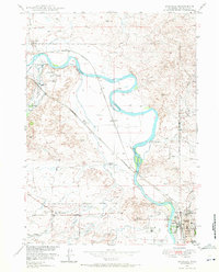
 1949 Irvine1960 Print · USGSThe North Platte River valley in the late 1940s reveals a landscape of irrigation and rail transport. Researchers can trace the Chicago and Northwestern line through Irvine or locate markers like Beacon 11A and Miller.2 unique versions available
 - 1949 Map of Douglas, 1971 Print
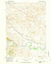
 1949 Douglas1971 Print · USGSDouglas and the surrounding Converse County ranchlands appear here in the late 1940s, anchored by the historical junction of the North Platte River and early migration routes. Researchers can trace the legacy of the Old West at the Site of Old Fort Fetterman, the Bozeman Trail, and the Bill Hooker Monument.3 unique versions available
 - 1949 Map of Chalk Buttes, 1975 Print
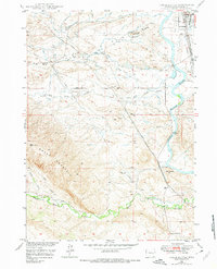 1949 Chalk Buttes1975 Print · USGSConverse County at the end of the 1940s shows a landscape where historic overland routes meet modern rail and aviation. Trace the path of the Emigrant Trail past the Oregon Trail Monument or locate early landmarks like the Municipal Airport and Hot Springs.3 unique versions available
 - 1949 Map of Antelope Creek, 1981 Print
 1949 Antelope Creek1981 Print · USGSRanching life in Converse County comes into focus in this late-1940s survey of the plains near Douglas. Researchers can locate family landmarks like Combs Ranch and Wallis Ranch, or trace the grounds of the Graves School (Abandoned).
End of results
Showing maps 1-4 of 4
Frequently asked questions
- What are the different types of historical maps available for Douglas?
- What is the oldest map of Douglas?
- Where can I purchase historical maps of Douglas for my home or office?
- Where can I download high-res historical maps of Douglas?
- Are there historical topographic maps available for Douglas?
- Is there historical aerial imagery available for Douglas?
- Where are historical maps of Douglas sourced from?