1970s Maps of Laramie County, Wyoming
Explore 2 historic maps of Laramie County from the 1970s. These maps offer a rare glimpse into what life looked like during the 1970s — showing old roads, neighborhoods, homes, and landmarks that have changed or disappeared over time.
Whether you're researching your family's past, planning a metal detecting trip, or studying how Laramie County's landscape evolved across the 1970s, these high-resolution maps are a powerful tool for exploring the history of this region.
- Focus on a specific era: All maps on this page are from the 1970s, giving you a focused view of this time period.
- See what’s changed: Compare century-old streets, trails, and buildings to today's modern landscape using overlays and satellite layers.
- Research with precision: Use these maps for genealogy, historical research, land use analysis, or educational projects.
- View, download, or print: Maps are fully viewable online in high resolution, and can be downloaded or printed for your own records.
Start exploring Laramie County's history through authentic maps from the 1970s. This is your window into the past.
Laramie County, WY maps
(2)- 1972 Map of Carr East, 1974 Print
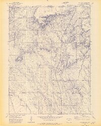 1972 Carr East1974 Print · USGSWeld County and the Wyoming borderlands are captured in the early seventies as a hub of ranching and rail activity. Genealogists and historians can trace family-named landmarks like Stephens Windmill and the settlement at Carr along the Union Pacific Railroad.3 unique versions available
 - 1972 Map of Carr West, 1974 Print
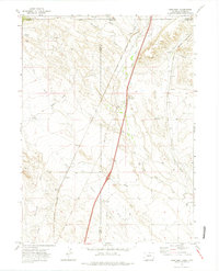 1972 Carr West1974 Print · USGSThe high plains border where Colorado meets Wyoming was a vital rail corridor in the early 1970s. Genealogists and rail historians can trace the paths of the Union Pacific and Colorado and Southern past Warren and the Natural Fort.3 unique versions available
End of results
Showing maps 1-2 of 2
Top cities of Laramie County
- Cheyenne historical maps
- Ranchettes historical maps
- South Greeley historical maps
- Fox Farm–College historical maps
- Warren Air Force Base historical maps
- Burns historical maps
See more
Frequently asked questions
- What are the different types of historical maps available for Laramie County?
- What is the oldest map of Laramie County?
- Where can I purchase historical maps of Laramie County for my home or office?
- Where can I download high-res historical maps of Laramie County?
- Are there historical topographic maps available for Laramie County?
- Is there historical aerial imagery available for Laramie County?
- Where are historical maps of Laramie County sourced from?