1980s Maps of Laramie County, Wyoming
Explore 9 historic maps of Laramie County from the 1980s. These maps offer a rare glimpse into what life looked like during the 1980s — showing old roads, neighborhoods, homes, and landmarks that have changed or disappeared over time.
Whether you're researching your family's past, planning a metal detecting trip, or studying how Laramie County's landscape evolved across the 1980s, these high-resolution maps are a powerful tool for exploring the history of this region.
- Focus on a specific era: All maps on this page are from the 1980s, giving you a focused view of this time period.
- See what’s changed: Compare century-old streets, trails, and buildings to today's modern landscape using overlays and satellite layers.
- Research with precision: Use these maps for genealogy, historical research, land use analysis, or educational projects.
- View, download, or print: Maps are fully viewable online in high resolution, and can be downloaded or printed for your own records.
Start exploring Laramie County's history through authentic maps from the 1980s. This is your window into the past.
Laramie County, WY maps
(9)- 1980 Map of Fort Collins, 1981 Print
 1980 Fort Collins1981 Print · USGSThe Front Range and high Rockies meet in Larimer County during the early 1980s. Local researchers can trace the growth of Fort Collins, the irrigation network around Wellington, and high-country outposts like Red Feather Lakes or the scenic canyon settlement of Mishawaka.
 - 1981 Map of Cheyenne
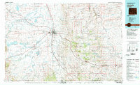
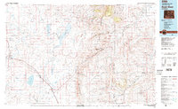
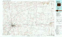 1981 Cheyenne1981 Print · USGSCheyenne and the surrounding high plains are captured here in the early eighties, showcasing the intersection of major rail lines and interstate highways. Genealogists and historians can trace the development of outlying ranching communities like Carpenter, Arcola, and the border town of Pine Bluffs.2 unique versions available
 - 1981 Map of Laramie
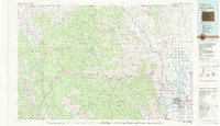
 1981 Laramie1981 Print · USGSLaramie and the high plains of the Laramie Mountains are captured here in the early eighties. Researchers can trace the Union Pacific rail stops, find Greenhill Cem, and locate early routes like the Overland Trail.2 unique versions available
 - 1982 Map of Eaton
 1982 Eaton1982 Print · USGSNorthern Colorado and the Wyoming borderlands are captured here in the early eighties, showcasing a vast agricultural and rail landscape. Trace family roots and vanished infrastructure through Chalk Bluffs, the Great Western railroad, and Keota.2 unique versions available
 - 1982 Map of Rock River
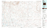
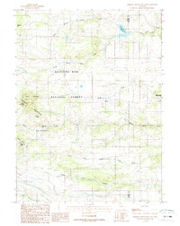
 1982 Rock River1982 Print · USGSThe Laramie Basin and the rugged peaks of the high plains come into focus in the early eighties. Genealogists and historians can trace rail-aligned settlements like Rock River and Bosler, alongside hydraulic landmarks like Wheatland Reservoir No 2.
 - 1987 Map of Green Top Mountain
 1987 Green Top Mountain1987 Print · USGSThe high country of the Medicine Bow front is captured here in the late eighties as it straddles the Albany and Laramie county line. Researchers can locate remote high-altitude landmarks like Eagle Rock, the secluded Grave, and several Mine sites near McKechnie Meadow.
 - 1987 Map of Sherman Mountains East
 1987 Sherman Mountains East1987 Print · USGSThe Laramie Range in the late eighties reveals a high-country landscape of granite formations and vital water catchments. Hikers and historians can trace the Old Railroad Grade or locate landmarks like Vedauwoo Glen and Hirsig.2 unique versions available
 - 1987 Map of Buford
 1987 Buford1987 Print · USGSHigh plains ranching and railroad history meet in the late 1980s at the Albany and Laramie county line. Genealogists and rail historians can trace the UNION PACIFIC route through historic stops at Sherman, Buford, and Harriman.
 - 1987 Map of Ragged Top Mountain, 1988 Print
 1987 Ragged Top Mountain1988 Print · USGSThe high rangelands of Albany County are documented here in the late eighties as a complex network of mountain forks and headwaters. Researchers can trace the drainage of North Fork Horse Creek and locate sites like the Mine Shaft or Quarry.
End of results
Showing maps 1-9 of 9
Top cities of Laramie County
- Cheyenne historical maps
- Ranchettes historical maps
- South Greeley historical maps
- Fox Farm–College historical maps
- Warren Air Force Base historical maps
- Burns historical maps
See more
Frequently asked questions
- What are the different types of historical maps available for Laramie County?
- What is the oldest map of Laramie County?
- Where can I purchase historical maps of Laramie County for my home or office?
- Where can I download high-res historical maps of Laramie County?
- Are there historical topographic maps available for Laramie County?
- Is there historical aerial imagery available for Laramie County?
- Where are historical maps of Laramie County sourced from?