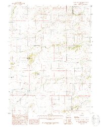
1987 Map of Ragged Top Mountain
USGS Topo · Published 1988About this map
The high-altitude drainage systems of Albany County and Laramie County define this 1987 survey, where the convergence of various watercourses shapes a landscape of significant peaks and technical land use. Ragged Top Mountain and Powell Mountain dominate the central terrain, serving as the source points for the complex Horse Creek watershed. The map details the intricate path of the North Fork Horse Creek as it winds through the foothills, eventually joined by the South Fork Horse Creek near the county line. Evidence of localized industry is clear, with a noted Mine Shaft and Quarry situated near the southern reaches of Horse Mountain. This document serves as a specialized record of Wyoming's water resource management and small-scale resource extraction at the close of the 1980s, highlighting remote water features like Horse Creek Lakes and various springs that sustain the surrounding rangeland.
Find a feature on this map
13 named features on this map. Tap any name to fly to it.
Don’t see what you’re looking for? This feature index may not catch every label — zoom into the map to look around manually.
Map Details
Editions of this 1987 Ragged Top Mountain Map
This is the sole edition of this map. No revisions or reprints were ever made.
Other maps of this area

1905 · Sherman
USGS Topo · 1:125,000

1948 · Ragged Top Mountain
USGS Topo · 1:62,500

1950 · Ragged Top Mountain
USGS Topo · 1:62,500

1954 · Cheyenne
USGS Topo · 1:250,000

1955 · Baldy Mountain
USGS Topo · 1:24,000

1955 · Goat Mountain
USGS Topo · 1:24,000

1958 · Cheyenne
USGS Topo · 1:250,000

1962 · Horse Creek
USGS Topo · 1:24,000

1962 · Farthing
USGS Topo · 1:24,000
1962 · Islay
USGS Topo · 1:24,000