1940s Maps of Natrona County, Wyoming
Explore 3 historic maps of Natrona County from the 1940s. These maps offer a rare glimpse into what life looked like during the 1940s — showing old roads, neighborhoods, homes, and landmarks that have changed or disappeared over time.
Whether you're researching your family's past, planning a metal detecting trip, or studying how Natrona County's landscape evolved across the 1940s, these high-resolution maps are a powerful tool for exploring the history of this region.
- Focus on a specific era: All maps on this page are from the 1940s, giving you a focused view of this time period.
- See what’s changed: Compare century-old streets, trails, and buildings to today's modern landscape using overlays and satellite layers.
- Research with precision: Use these maps for genealogy, historical research, land use analysis, or educational projects.
- View, download, or print: Maps are fully viewable online in high resolution, and can be downloaded or printed for your own records.
Start exploring Natrona County's history through authentic maps from the 1940s. This is your window into the past.
Natrona County, WY maps
(3)- 1949 Map of Brookhurst, 1958 Print
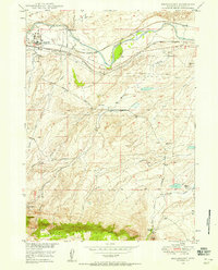 1949 Brookhurst1958 Print · USGSNatrona County in the late 1940s shows a landscape shaped by the river and the rail, just as the regional oil industry was maturing. Researchers can trace family ranch lands like Jones Ranch, locate the rural Muddy Sch, and follow the Burlington and Quincy railroad through Brookhurst.
 - 1949 Map of Campbell Hill, 1958 Print
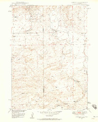 1949 Campbell Hill1958 Print · USGSThe high plains of the Converse and Natrona county line are shown here in the late 1940s as petroleum development took hold. Researchers can locate early oil infrastructure at the Cole Creek Oil Field and trace legacy family holdings like the K Lazy S Ranch or the Dewitt Ranch.3 unique versions available
 - 1949 Map of Pratts Soda Lakes, 1975 Print
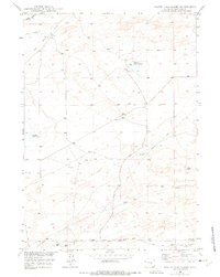 1949 Pratts Soda Lakes1975 Print · USGSNatrona County at the end of the 1940s shows a landscape where historic pioneer paths meet modern industry. Trace the route of the Emigrant Trail past the Blue Rock Coal Mine and the distinctive Pratts Soda Lakes.2 unique versions available
End of results
Showing maps 1-3 of 3
Top cities of Natrona County
- Casper historical maps
- Mills historical maps
- Bar Nunn historical maps
- Evansville historical maps
- Vista West historical maps
- Hartrandt historical maps
See more
Frequently asked questions
- What are the different types of historical maps available for Natrona County?
- What is the oldest map of Natrona County?
- Where can I purchase historical maps of Natrona County for my home or office?
- Where can I download high-res historical maps of Natrona County?
- Are there historical topographic maps available for Natrona County?
- Is there historical aerial imagery available for Natrona County?
- Where are historical maps of Natrona County sourced from?