1970s Maps of Natrona County, Wyoming
Explore 3 historic maps of Natrona County from the 1970s. These maps offer a rare glimpse into what life looked like during the 1970s — showing old roads, neighborhoods, homes, and landmarks that have changed or disappeared over time.
Whether you're researching your family's past, planning a metal detecting trip, or studying how Natrona County's landscape evolved across the 1970s, these high-resolution maps are a powerful tool for exploring the history of this region.
- Focus on a specific era: All maps on this page are from the 1970s, giving you a focused view of this time period.
- See what’s changed: Compare century-old streets, trails, and buildings to today's modern landscape using overlays and satellite layers.
- Research with precision: Use these maps for genealogy, historical research, land use analysis, or educational projects.
- View, download, or print: Maps are fully viewable online in high resolution, and can be downloaded or printed for your own records.
Start exploring Natrona County's history through authentic maps from the 1970s. This is your window into the past.
Natrona County, WY maps
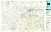
(3)- 1979 Map of Nowater Creek, 1980 Print
 1979 Nowater Creek1980 Print · USGSWashakie County ranch lands and drainage basins are captured in detail during the late seventies, showing a landscape of scattered oil fields and seasonal watercourses. Genealogists and historians can trace the Burlington Northern rail line and remote outposts like Nowood and Hampton Ranch.
 - 1979 Map of Casper, 1980 Print
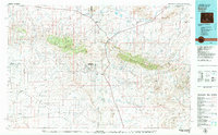
 1979 Casper1980 Print · USGSCasper and the North Platte River valley are documented here during the late seventies, showing the city's growth against the backdrop of the Laramie Mountains. Researchers can trace the historic Emigrant Trail past Bessemer Mountain or locate family plots at Highland Cem.
 - 1979 Map of Bairoil, 1980 Print
 1979 Bairoil1980 Print · USGSSouth-central Wyoming in the late 1970s was a landscape of remote energy outposts and high-desert ranges. Researchers can trace the industrial footprint of the Sunday Morning Mine and settlements like Bairoil and Jeffrey City.
End of results
Showing maps 1-3 of 3
Top cities of Natrona County
- Casper historical maps
- Mills historical maps
- Bar Nunn historical maps
- Evansville historical maps
- Vista West historical maps
- Hartrandt historical maps
See more
Frequently asked questions
- What are the different types of historical maps available for Natrona County?
- What is the oldest map of Natrona County?
- Where can I purchase historical maps of Natrona County for my home or office?
- Where can I download high-res historical maps of Natrona County?
- Are there historical topographic maps available for Natrona County?
- Is there historical aerial imagery available for Natrona County?
- Where are historical maps of Natrona County sourced from?