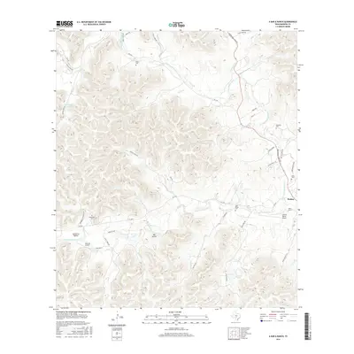
2016 Map of A Bar A Ranch
USGS Topo · Published 2016About this map
The N Prong Medina River and W Prong Medina River converge near the settlement of Medina, anchoring a landscape defined by deeply carved drainages and isolated ranching outposts. This 2016 survey highlights the intricate network of watercourses that feed the Medina system, including Rocky Cr, Pecan Cr, and Elm Cr. For local historians and genealogists, the map is a precise record of family legacy on the land, preserving the locations of the Means Cem, Goodman Cem, and Baker Cem. Private aviation and large-scale ranching operations are prominent, noted by the A Bar A Ranch, the Cinco B Ranch Airport, and Idlewild Airport. This modern record of Bandera County shows how historical crossing points, such as Bauerlein Crossings Rd, continue to define the movement of people and livestock through the hills.
Find a feature on this map
55 named features on this map. Tap any name to fly to it.
Don’t see what you’re looking for? This feature index may not catch every label — zoom into the map to look around manually.
Map Details
Editions of this 2016 A Bar A Ranch Map
This is the sole edition of this map. No revisions or reprints were ever made.
Other maps of this area

1954 · San Antonio
USGS Topo · 1:250,000

1956 · Tarpley
USGS Topo · 1:62,500

1956 · Tuff
USGS Topo · 1:62,500

1956 · Bandera
USGS Topo · 1:62,500

1956 · Center Point
USGS Topo · 1:62,500

1957 · San Antonio
USGS Topo · 1:250,000

1964 · Diamond S Ranch
USGS Topo · 1:24,000

1964 · Echo Hill Ranch
USGS Topo · 1:24,000
1964 · Love Creek
USGS Topo · 1:24,000

1964 · Rock Cliff Reservoir
USGS Topo · 1:24,000