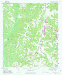
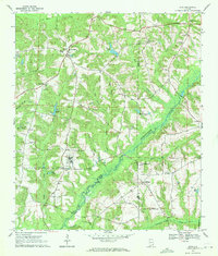
1969 Map of Abbeville West
USGS Topo · Published 1981About this map
Abbeville and its western rural surroundings define this landscape, where the Seaboard Coast Line railroad creates a distinct corridor through the agricultural terrain. This period shows a community structured around its spiritual and educational centers, including the County Training Sch and several prominent local churches such as Bethlehem Ch and Pleasant Grove Ch. The topography is dominated by the East Fork Choctawhatchee River and its numerous tributaries, including Fatty Creek and Poor Creek, which carve through the woodland and farmland. Cultural landmarks of the era are well-documented, from the Drive-in Theater and Radio Tower (WARI) near Graball to the Abbeville Lookout Tower on the town's northern edge. For researchers of family history, the map preserves the locations of several smaller burial grounds, such as Hutto Cem and Danzey Cem, situated near traditional farmsteads.
Find a feature on this map
39 named features on this map. Tap any name to fly to it.
Don’t see what you’re looking for? This feature index may not catch every label — zoom into the map to look around manually.
Map Details
Editions of this 1969 Abbeville West Map
2 editions found
Other maps of this area

1953 · Dothan
USGS Topo · 1:250,000

1954 · Dothan
USGS Topo · 1:250,000

1955 · Dothan
USGS Topo · 1:250,000

1969 · Abbeville West
USGS Topo · 1:24,000

1969 · Fort Gaines NW
USGS Topo · 1:24,000
1969 · Texasville
USGS Topo · 1:24,000
1969 · Clopton
USGS Topo · 1:24,000
1969 · Lawrenceville
USGS Topo · 1:24,000

1969 · Abbeville East
USGS Topo · 1:24,000
1969 · Echo
USGS Topo · 1:24,000