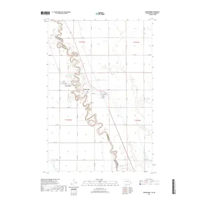
2017 Map of Abercrombie
USGS Topo · Published 2017About this map
The Red River of the North winds in sharp, serpentine meanders along the border of North Dakota and Minnesota, defining the boundary between Wilkin and Richland counties. This landscape is shaped by the fertile plains of the Red River Valley, where the river's path is so complex that it creates numerous oxbows and narrow peninsulas. On the western bank in North Dakota, the town of Abercrombie sits near the confluence where Nyquist Coulee meets the main channel. Across the river in Minnesota, the small settlements of McCauleyville and Kent are situated along the river's edge. Local history and genealogy researchers can locate the Saint Thomas Cem and McCauleyville Cem near the riverbanks. The drainage of this agricultural region is further detailed by the Wild Rice River, Whisky Cr, and man-made channels like Country Ditch Number One-A.
Find a feature on this map
39 named features on this map. Tap any name to fly to it.
Don’t see what you’re looking for? This feature index may not catch every label — zoom into the map to look around manually.
Map Details
Editions of this 2017 Abercrombie Map
This is the sole edition of this map. No revisions or reprints were ever made.
Other maps of this area

1895 · Fargo
USGS Topo · 1:125,000

1897 · Fargo
USGS Topo · 1:125,000

1904 · Wahpeton
USGS Topo · 1:125,000

1953 · Fargo
USGS Topo · 1:250,000

1956 · Fargo
USGS Topo · 1:250,000

1959 · Christine
USGS Topo · 1:24,000

1960 · Galchutt
USGS Topo · 1:24,000

1960 · Mooreton East
USGS Topo · 1:24,000

1964 · Dwight
USGS Topo · 1:24,000

1964 · Wahpeton
USGS Topo · 1:24,000