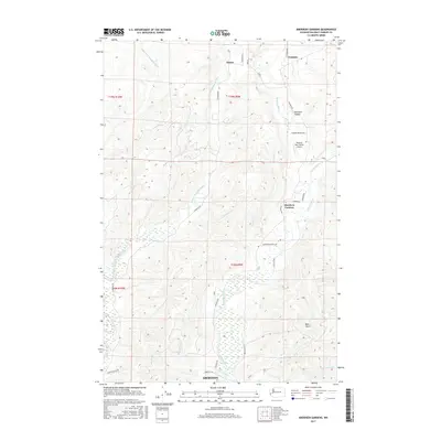
2017 Map of Aberdeen Gardens
USGS Topo · Published 2017About this map
The Wishkah River and its multiple branches define this landscape north of Aberdeen, where the coastal lowlands of Grays Harbor County meet the rising terrain of the Olympic Peninsula. This 2017 study illustrates the residential expansion at Aberdeen Gardens and the small settlement of Wishkah, tucked into the river valleys. The area's geography is deeply intersected by waterways like the Middle Fork Hoquiam River and E Fork Hoquiam River, which have historically driven the local timber and agricultural economy. Notable landmarks include the Wishkah River Ranch Airport and significant topographical features such as Hamilton Canyon and Bear Gulch. The road network, including Wishkah Rd and E Hoquiam Rd, follows the natural contours of the river banks, connecting isolated outposts like Nisson to the larger city center to the south.
Find a feature on this map
36 named features on this map. Tap any name to fly to it.
Don’t see what you’re looking for? This feature index may not catch every label — zoom into the map to look around manually.
Map Details
Editions of this 2017 Aberdeen Gardens Map
This is the sole edition of this map. No revisions or reprints were ever made.
Other maps of this area

1940 · Montesano
USGS Topo · 1:62,500

1941 · Mobray
USGS Topo · 1:62,500

1943 · Humptulips
USGS Topo · 1:62,500

1943 · Mobray
USGS Topo · 1:62,500

1953 · Hoquiam
USGS Topo · 1:250,000

1955 · Montesano
USGS Topo · 1:62,500

1955 · Wynoochee Valley
USGS Topo · 1:62,500

1955 · Humptulips
USGS Topo · 1:62,500

1957 · Hoquiam
USGS Topo · 1:250,000
1957 · Hoquiam
USGS Topo · 1:24,000