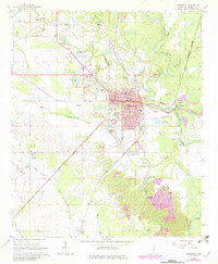
1966 Map of Aberdeen
USGS Topo · Published 1982About this map
The Aberdeen city center occupies a high terrace west of the Tombigbee River, serving as a vital Mississippi river and rail hub. By the mid-1960s, the community’s infrastructure included the Gulf Central Illinois Railroad and the Burlington Northern lines, supporting local industry and the transit of goods. The landscape is dotted with rural landmarks essential for genealogical research, such as the Odd Fellows Cemetery, Cem Friendship Ch, and James Creek Ch Cem.
Find a feature on this map
48 named features on this map. Tap any name to fly to it.
Don’t see what you’re looking for? This feature index may not catch every label — zoom into the map to look around manually.
Map Details
Editions of this 1966 Aberdeen Map
2 editions found
Other maps of this area

1953 · West Point
USGS Topo · 1:250,000

1958 · West Point
USGS Topo · 1:250,000

1959 · West Point
USGS Topo · 1:62,500

1960 · Caledonia
USGS Topo · 1:62,500

1963 · West Point
USGS Topo · 1:250,000

1965 · Egypt
USGS Topo · 1:24,000

1966 · Aberdeen
USGS Topo · 1:24,000

1966 · Amory
USGS Topo · 1:24,000

1966 · Amory SW
USGS Topo · 1:24,000

1966 · Wren
USGS Topo · 1:24,000