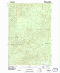
1955 Map of Aberdeen SE
USGS Topo · Published 1995About this map
The North River dominates this mid-century landscape of the Pacific Northwest, winding through a complex drainage basin defined by the Divide. The network of watercourses, including the South Fork Johns River and the East Fork, highlights a region deeply tied to the timber and natural resource economy. Access into the timberlands is traced by the American Mill Road and Lund Road, while industrial activity is noted at the local Quarry and a Gaging Sta along the riverbank.
Find a feature on this map
21 named features on this map. Tap any name to fly to it.
Don’t see what you’re looking for? This feature index may not catch every label — zoom into the map to look around manually.
Map Details
Editions of this 1955 Aberdeen SE Map
2 editions found
Other maps of this area

1938 · South Bend
USGS Topo · 1:62,500

1940 · Montesano
USGS Topo · 1:62,500

1940 · South Bend
USGS Topo · 1:62,500

1953 · Hoquiam
USGS Topo · 1:250,000

1955 · Montesano
USGS Topo · 1:62,500

1955 · Raymond
USGS Topo · 1:62,500

1955 · Aberdeen SE
USGS Topo · 1:24,000

1956 · Western
USGS Topo · 1:24,000

1957 · Hoquiam
USGS Topo · 1:250,000
1957 · Bay Center
USGS Topo · 1:24,000