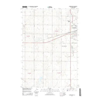
2015 Map of Aberdeen West
USGS Topo · Published 2015About this map
Aberdeen anchors the eastern edge of this prairie landscape, showing the city's residential expansion into the Harlin Addition and Derian Subdivision. The transition from the structured street grid of the city to the expansive section-line roads of Brown County illustrates the modern development of this South Dakota hub. Natural and recreational water features define the local geography, from the winding path of Foot Creek to the waters of Wylie Lake and the more remote Lords Lake to the south. Local history is grounded in sites like Riverside Cem, while a dense network of numbered avenues and streets—such as 135th St and 382nd Ave—marks the transition into the productive agricultural hinterland of Township 123 North, Range 64 West.
Find a feature on this map
55 named features on this map. Tap any name to fly to it.
Don’t see what you’re looking for? This feature index may not catch every label — zoom into the map to look around manually.
Map Details
Editions of this 2015 Aberdeen West Map
This is the sole edition of this map. No revisions or reprints were ever made.
Other maps of this area

1894 · Columbia
USGS Topo · 1:62,500

1895 · Aberdeen
USGS Topo · 1:125,000

1896 · Columbia
USGS Topo · 1:125,000

1899 · Ellendale
USGS Topo · 1:125,000

1899 · Northville
USGS Topo · 1:125,000

1952 · Ordway
USGS Topo · 1:24,000

1953 · Warner
USGS Topo · 1:24,000

1954 · Aberdeen
USGS Topo · 1:250,000

1956 · Aberdeen
USGS Topo · 1:250,000
1960 · Aberdeen East
USGS Topo · 1:24,000