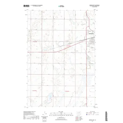
2017 Map of Aberdeen West
USGS Topo · Published 2017About this map
The western edge of Aberdeen gives way to the open plains of Brown County, where the city's residential grid transitions into a systematic network of section roads. This 2017 survey shows the city's westward expansion reaching toward Wylie Lake and the meandering path of Foot Creek. The landscape is defined by the rigid township and range lines of the Public Land Survey System, specifically t123n r64w and t122n r64w, which dictate the placement of rural thoroughfares like Davis Rd and 135th St. To the south, Lords Lake sits within a complex of wetlands, illustrating the natural prairie pothole topography that persists alongside agricultural development and the growing suburban footprint of the regional hub.
Find a feature on this map
37 named features on this map. Tap any name to fly to it.
Don’t see what you’re looking for? This feature index may not catch every label — zoom into the map to look around manually.
Map Details
Editions of this 2017 Aberdeen West Map
This is the sole edition of this map. No revisions or reprints were ever made.
Other maps of this area

1894 · Columbia
USGS Topo · 1:62,500

1895 · Aberdeen
USGS Topo · 1:125,000

1896 · Columbia
USGS Topo · 1:125,000

1899 · Ellendale
USGS Topo · 1:125,000

1899 · Northville
USGS Topo · 1:125,000

1952 · Ordway
USGS Topo · 1:24,000

1953 · Warner
USGS Topo · 1:24,000

1954 · Aberdeen
USGS Topo · 1:250,000

1956 · Aberdeen
USGS Topo · 1:250,000
1960 · Aberdeen East
USGS Topo · 1:24,000