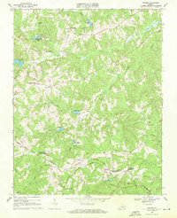
1968 Map of Abilene
USGS Topo · Published 1971About this map
Norfolk and Western rail lines slice through the rural borderlands between Prince Edward and Charlotte Counties, anchoring small communities like Abilene and Darlington Heights. This late-1960s landscape is defined by its numerous rural congregations and cemeteries, which serve as historical touchstones for the area. Significant local landmarks include Buffalo Ch, Bethpeor Ch, and New Hope Ch, alongside family and church burial grounds like St Ann Cem and Willow Grove Ch Cem.
Find a feature on this map
39 named features on this map. Tap any name to fly to it.
Don’t see what you’re looking for? This feature index may not catch every label — zoom into the map to look around manually.
Map Details
Editions of this 1968 Abilene Map
3 editions found
Other maps of this area

1891 · Farmville
USGS Topo · 1:125,000

1892 · Appomattox
USGS Topo · 1:125,000

1893 · Farmville
USGS Topo · 1:125,000

1947 · Roanoke
USGS Topo · 1:250,000

1956 · Charlotte Court House
USGS Topo · 1:62,500

1958 · Farmville
USGS Topo · 1:62,500

1958 · Keysville
USGS Topo · 1:62,500

1958 · Pamplin City
USGS Topo · 1:62,500

1959 · Roanoke
USGS Topo · 1:250,000

1963 · Roanoke
USGS Topo · 1:250,000