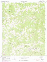
1968 Map of Abilene
USGS Topo · Published 1981About this map
The Norfolk and Western railroad corridor defines the southern landscape of this 1968 survey, connecting the settlement of Abilene to the surrounding rural Piedmont. This area, straddling the Prince Edward Co Charlotte Co line, is characterized by a dense network of small community centers and country churches. Numerous spiritual and social hubs are documented, including Buffalo Ch, Bethlehem Ch, and Beulah Ch, often accompanied by family and community burial grounds such as the Spring Creek Ch Cem.
Find a feature on this map
42 named features on this map. Tap any name to fly to it.
Don’t see what you’re looking for? This feature index may not catch every label — zoom into the map to look around manually.
Map Details
Editions of this 1968 Abilene Map
3 editions found
Other maps of this area

1891 · Farmville
USGS Topo · 1:125,000

1892 · Appomattox
USGS Topo · 1:125,000

1893 · Farmville
USGS Topo · 1:125,000

1947 · Roanoke
USGS Topo · 1:250,000

1956 · Charlotte Court House
USGS Topo · 1:62,500

1958 · Farmville
USGS Topo · 1:62,500

1958 · Keysville
USGS Topo · 1:62,500

1958 · Pamplin City
USGS Topo · 1:62,500

1959 · Roanoke
USGS Topo · 1:250,000

1963 · Roanoke
USGS Topo · 1:250,000