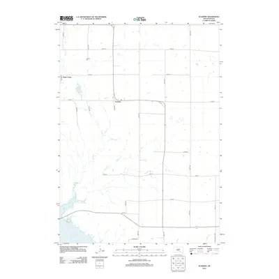
2012 Map of Academy
USGS Topo · Published 2012About this map
Academy and the surrounding agricultural townships of Charles Mix County are defined by a strict section-line road grid and the meandering path of Snake Cr. In the northwest, Platte Colony stands as a notable communal settlement, while LaRoche Cem provides a point of genealogical interest for those tracing family roots in this rural prairie landscape. The southwestern corner of the map reaches the expansive waters of Lake Francis Case, a reservoir on the Missouri River that dramatically alters the local topography compared to the upland plains to the east. Smaller hydrological features like Academy Lake and Fiv emile Cr interrupt the vast stretches of farmland. The transportation network is anchored by S Dakota Hwy 1804 and a series of numbered local routes including 271st St and 354th Ave, reflecting the modern infrastructure used to navigate this sparsely populated region.
Find a feature on this map
23 named features on this map. Tap any name to fly to it.
Don’t see what you’re looking for? This feature index may not catch every label — zoom into the map to look around manually.
Map Details
Editions of this 2012 Academy Map
This is the sole edition of this map. No revisions or reprints were ever made.
Other maps of this area

1955 · Mitchell
USGS Topo · 1:250,000

1959 · Mitchell
USGS Topo · 1:250,000

1971 · Lucas NW
USGS Topo · 1:24,000

1971 · Academy
USGS Topo · 1:24,000

1971 · Lucas
USGS Topo · 1:24,000

1971 · Lucas SE
USGS Topo · 1:24,000

1979 · Castalia
USGS Topo · 1:24,000

1979 · Eagle
USGS Topo · 1:24,000
1979 · Bijou Hills
USGS Topo · 1:24,000

1979 · Lake George
USGS Topo · 1:24,000
Featured Places
- Lake George Township, SD
- La Roche Township, SD
- Pleasant Grove Township, SD
- Castalia Township, SD
- Eagle Township, SD