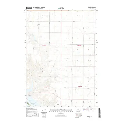
2015 Map of Academy
USGS Topo · Published 2015About this map
Academy serves as a central hub in this section of Charles Mix County, situated atop the plains north of the Missouri River. The landscape is defined by the transition from upland agricultural fields to the dissected bluffs leading down to Lake Francis Case. This massive reservoir on the Missouri River is crossed here by the Platte-Winner Bridge, a vital transportation link connecting Charles Mix and Gregory counties. The interior drainage is characterized by seasonal watercourses like Snake Cr, which feeds into Academy Lake. For local history researchers, the map identifies the LaRoche Cem and the Platte Colony, reflecting the communal and family-centered settlement patterns of the South Dakota prairie. The geometric precision of the township and range system is evident in the grid of section roads, including 355th Ave and 271st St, which navigate the varying elevations of the river breaks.
Find a feature on this map
33 named features on this map. Tap any name to fly to it.
Don’t see what you’re looking for? This feature index may not catch every label — zoom into the map to look around manually.
Map Details
Editions of this 2015 Academy Map
This is the sole edition of this map. No revisions or reprints were ever made.
Other maps of this area

1955 · Mitchell
USGS Topo · 1:250,000

1959 · Mitchell
USGS Topo · 1:250,000

1971 · Lucas NW
USGS Topo · 1:24,000

1971 · Academy
USGS Topo · 1:24,000

1971 · Lucas
USGS Topo · 1:24,000

1971 · Lucas SE
USGS Topo · 1:24,000

1979 · Castalia
USGS Topo · 1:24,000

1979 · Eagle
USGS Topo · 1:24,000
1979 · Bijou Hills
USGS Topo · 1:24,000

1979 · Lake George
USGS Topo · 1:24,000
Featured Places
- Lake George Township, SD
- La Roche Township, SD
- Pleasant Grove Township, SD
- Castalia Township, SD
- Eagle Township, SD