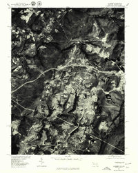
1977 Map of Accident
USGS Topo · Published 1979About this map
Accident, Maryland, and the surrounding Garrett County landscape are captured in this 1970s orthophotograph, providing a detailed visual of the agricultural patterns and wooded ridges of the Allegheny Plateau. The aerial perspective reveals the clear boundary between cultivated fields and the steep, forested slopes of Rich Hill, while the path of Bear Creek cuts through the southern portion of the quadrangle. Unlike traditional line maps, this imagery, prepared in cooperation with the Soil Conservation Service, allows for the direct observation of individual farmsteads, woodlots, and the winding road network as they existed in April 1977. The settlement at Accident is shown concentrated along the valley floor, highlighting its historical role as a local hub amidst the high-elevation terrain of western Maryland.
Find a feature on this map
3 named features on this map. Tap any name to fly to it.
Don’t see what you’re looking for? This feature index may not catch every label — zoom into the map to look around manually.
Map Details
Editions of this 1977 Accident Map
This is the sole edition of this map. No revisions or reprints were ever made.
Other maps of this area

1899 · Grantsville
USGS Topo · 1:62,500

1900 · Accident
USGS Topo · 1:62,500

1904 · Grantsville
USGS Topo · 1:62,500

1921 · Meyersdale
USGS Topo · 1:62,500

1922 · Confluence
USGS Topo · 1:62,500

1931 · Confluence
USGS Topo · 1:62,500

1933 · Confluence
USGS Topo · 1:62,500

1939 · Meyersdale
USGS Topo · 1:62,500

1944 · Meyersdale
USGS Topo · 1:62,500

1946 · Grantsville
USGS Topo · 1:24,000