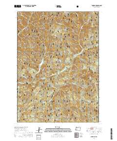
2020 Map of Acker Rock
USGS Topo · Published 2020About this map
The South Umpqua River carves through the heart of the Umpqua National Forest, defining a landscape of high summits and deep drainages. This high-country region is anchored by prominent landmarks such as Flagstone Peak to the north and the namesake Acker Rock in the east. Along the river's course, the South Umpqua Falls provides a significant geographic marker for the area's hydrology. The map details a network of Forest Service roads, including Nfst-2700843 and Nfst-2921231, which provide access to remote locations like Andraieff Meadows and Times Square Rock. Further south, the terrain rises toward Coyote Point and Junction Spring, where numerous tributaries like Coyote Cr and Tallow Cr feed back into the river system. The presence of established township and range lines, such as t28s r1e and t29s r2e, reflects the structured surveying of this timber-rich portion of Douglas County.
Find a feature on this map
41 named features on this map. Tap any name to fly to it.
Don’t see what you’re looking for? This feature index may not catch every label — zoom into the map to look around manually.
Map Details
Editions of this 2020 Acker Rock Map
This is the sole edition of this map. No revisions or reprints were ever made.
Other maps of this area

1891 · Ashland
USGS Topo · 1:250,000

1893 · Ashland
USGS Topo · 1:250,000

1897 · Ashland
USGS Topo · 1:250,000

1944 · Tiller
USGS Topo · 1:62,500

1944 · Abbott Butte
USGS Topo · 1:62,500

1947 · Abbott Butte
USGS Topo · 1:62,500

1955 · Quartz Mtn
USGS Topo · 1:62,500

1955 · Red Butte
USGS Topo · 1:62,500

1955 · Medford
USGS Topo · 1:250,000

1957 · Medford
USGS Topo · 1:250,000