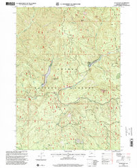
1998 Map of Acker Rock
USGS Topo · Published 2000About this map
Umpqua National Forest defines this drainage basin in Douglas County, where the South Umpqua River carves a deep valley fed by numerous tributaries like Boulder Creek and Quartz Creek. The 1998 revision highlights a landscape shaped by both geological features and Forest Service infrastructure, most notably the South Umpqua Falls Campground situated near the prominent South Umpqua Falls. High-elevation landmarks such as Flagstone Peak, Acker Rock, and Coyote Point provide clear orientation points across the timbered ridges. The presence of several Quarry sites and a network of Forest Service roads indicates the ongoing role of resource management and industrial access within the forest. Unique named locations like Andraieff Meadows and the whimsical Times Square Rock offer specific targets for local history research and backcountry exploration.
Find a feature on this map
26 named features on this map. Tap any name to fly to it.
Don’t see what you’re looking for? This feature index may not catch every label — zoom into the map to look around manually.
Map Details
Editions of this 1998 Acker Rock Map
This is the sole edition of this map. No revisions or reprints were ever made.
Other maps of this area

1891 · Ashland
USGS Topo · 1:250,000

1893 · Ashland
USGS Topo · 1:250,000

1897 · Ashland
USGS Topo · 1:250,000

1944 · Tiller
USGS Topo · 1:62,500

1944 · Abbott Butte
USGS Topo · 1:62,500

1947 · Abbott Butte
USGS Topo · 1:62,500

1955 · Quartz Mtn
USGS Topo · 1:62,500

1955 · Red Butte
USGS Topo · 1:62,500

1955 · Medford
USGS Topo · 1:250,000

1957 · Medford
USGS Topo · 1:250,000