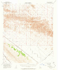
1953 Map of Acolita
USGS Topo · Published 1963About this map
The Southern Pacific railroad corridor defines the development of this desert landscape, anchored by the small station at Acolita. Surveyed in the early 1950s, the terrain is characterized by the high peaks of the Chocolate Mountains and the Chuckwalla Mountains, separated by the broad drainage of Mammoth Wash. Extensive sections of the map are partitioned by the Naval Reservation Boundary, indicating the mid-century military presence in the Imperial Valley region.
Find a feature on this map
17 named features on this map. Tap any name to fly to it.
Don’t see what you’re looking for? This feature index may not catch every label — zoom into the map to look around manually.
Map Details
Editions of this 1953 Acolita Map
5 editions found

Other maps of this area

1903 · Yuma
USGS Topo · 1:125,000

1905 · Yuma
USGS Topo · 1:125,000

1907 · Holtville
USGS Topo · 1:125,000

1940 · Iris
USGS Topo · 1:62,500

1940 · Iris Pass
USGS Topo · 1:62,500

1940 · Alamorio
USGS Topo · 1:62,500

1942 · El Centro
USGS Topo · 1:250,000

1942 · Yuma
USGS Topo · 1:250,000

1942 · Blythe
USGS Topo · 1:250,000

1945 · Alamorio
USGS Topo · 1:62,500