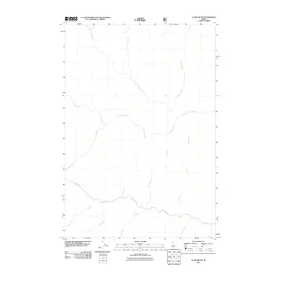
2011 Map of Acorn Butte
USGS Topo · Published 2011About this map
Crooked Creek and its many tributaries define this drainage-heavy landscape within the Nez Perce National Forest of Idaho County. This 2011 survey illustrates a sophisticated network of waterways that flow through high-elevation terrain, converging to feed the larger systems of central Idaho. Major branches like West Fork Crooked Creek and East Fork Crooked Creek dictate the local topography, while smaller drainages such as Silver Creek and Pack Horse Creek carve into the northern slopes. Further south, Big Creek serves as a primary drainage corridor, receiving inflow from Acorn Creek, Bull Creek, and Routson Creek. The absence of named settlements or heavy infrastructure highlights the wilderness character of the Acorn Butte area, where the names themselves—such as Bismark Creek and Coxey Creek—often trace back to early mining prospects or historical forest management names from the region's development.
Find a feature on this map
14 named features on this map. Tap any name to fly to it.
Don’t see what you’re looking for? This feature index may not catch every label — zoom into the map to look around manually.
Map Details
Editions of this 2011 Acorn Butte Map
This is the sole edition of this map. No revisions or reprints were ever made.
Other maps of this area

1956 · Elk City
USGS Topo · 1:250,000

1960 · Elk City
USGS Topo · 1:250,000

1962 · Mormon Mtn
USGS Topo · 1:24,000

1962 · Vinegar Hill
USGS Topo · 1:24,000

1973 · Center Mtn
USGS Topo · 1:24,000

1973 · Acorn Butte
USGS Topo · 1:24,000

1973 · Bismark Mtn
USGS Topo · 1:24,000
1973 · Monument
USGS Topo · 1:24,000

1978 · Wapiti Creek
USGS Topo · 1:24,000
1978 · Lodgepole Creek
USGS Topo · 1:24,000