
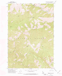
1962 Map of Mormon Mtn
USGS Topo · Published 1963About this map
Payette National Forest and a portion of the Salmon National Forest dominate this mid-century topographic study of the central Idaho backcountry. The landscape is defined by the sharp relief of Big Creek Ridge and high peaks like Mormon Mtn and Sheep Horn Mtn. Mapping from 1957 aerial photography captures the drainage patterns of Big Creek, which flows past a Gaging Station and the Lobauer Basin. A network of creek-cut canyons and high-elevation basins, including Browns Basin and Doe Canyon, shows a wilderness region managed for fire surveillance and resource protection. Evidence of this oversight is visible at Rush Creek Point Lookout, situated on a high point above Rush Creek. The map provides a detailed view of the terrain before later designations, focusing on the complex hydrology of the South Fork and its tributaries like Soldier Cr.
Find a feature on this map
21 named features on this map. Tap any name to fly to it.
Don’t see what you’re looking for? This feature index may not catch every label — zoom into the map to look around manually.
Map Details
Editions of this 1962 Mormon Mtn Map
2 editions found
Other maps of this area

1930 · Casto
USGS Topo · 1:125,000

1956 · Elk City
USGS Topo · 1:250,000

1957 · Challis
USGS Topo · 1:250,000

1960 · Elk City
USGS Topo · 1:250,000

1960 · Challis
USGS Topo · 1:250,000

1962 · Vinegar Hill
USGS Topo · 1:24,000

1962 · Bear Creek Point
USGS Topo · 1:24,000

1962 · Papoose Peak
USGS Topo · 1:24,000

1962 · Shellrock Peak
USGS Topo · 1:24,000

1962 · Dave Lewis Peak
USGS Topo · 1:24,000