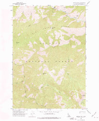
1962 Map of Mormon Mtn
USGS Topo · Published 1975About this map
Big Creek flows through the northern reaches of the Payette National Forest, carving a deep Canyon that defines the local topography in the early 1960s. High-altitude landmarks dominate the skyline, including the Rush Creek Point Lookout perched atop Big Creek Ridge and the prominent peak of Mormon Mtn in the southeast corner. The terrain is characterized by high basins like Browns Basin and Lobauer Basin, while a remote Gaging Station on the river indicates the technical monitoring of these mountain waters.
Find a feature on this map
21 named features on this map. Tap any name to fly to it.
Don’t see what you’re looking for? This feature index may not catch every label — zoom into the map to look around manually.
Map Details
Editions of this 1962 Mormon Mtn Map
2 editions found
Other maps of this area

1930 · Casto
USGS Topo · 1:125,000

1956 · Elk City
USGS Topo · 1:250,000

1957 · Challis
USGS Topo · 1:250,000

1960 · Elk City
USGS Topo · 1:250,000

1960 · Challis
USGS Topo · 1:250,000

1962 · Mormon Mtn
USGS Topo · 1:24,000

1962 · Vinegar Hill
USGS Topo · 1:24,000

1962 · Bear Creek Point
USGS Topo · 1:24,000

1962 · Papoose Peak
USGS Topo · 1:24,000

1962 · Shellrock Peak
USGS Topo · 1:24,000