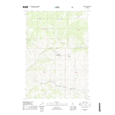
2020 Map of Acorn Butte
USGS Topo · Published 2020About this map
Acorn Butte and the surrounding wilderness of the Payette National Forest dominate this landscape along the boundary of Idaho and Valley counties. The area is defined by a dense network of high-altitude drainages, including Silver Creek, Crooked Creek, and the significant course of Big Creek to the south. A unique concentration of sandbars with whimsical names—Hard Boil Bar, Over Easy Bar, and Soft Boil Bar—suggests a localized culture of riverside recreation or specific mining-era humor along the water. The presence of Mile Flat and several extensive openings like Cold Meadows and Crescent Meadow provides a distinct contrast to the steep, dissected terrain of Bismark Basin. Local landmarks like Lookout Mountain and Coxey Hole further ground the geography, reflecting the navigational needs of foresters and backcountry travelers in this roadless interior.
Find a feature on this map
49 named features on this map. Tap any name to fly to it.
Don’t see what you’re looking for? This feature index may not catch every label — zoom into the map to look around manually.
Map Details
Editions of this 2020 Acorn Butte Map
This is the sole edition of this map. No revisions or reprints were ever made.
Other maps of this area

1956 · Elk City
USGS Topo · 1:250,000

1960 · Elk City
USGS Topo · 1:250,000

1962 · Mormon Mtn
USGS Topo · 1:24,000

1962 · Vinegar Hill
USGS Topo · 1:24,000

1973 · Center Mtn
USGS Topo · 1:24,000

1973 · Acorn Butte
USGS Topo · 1:24,000

1973 · Bismark Mtn
USGS Topo · 1:24,000
1973 · Monument
USGS Topo · 1:24,000

1978 · Wapiti Creek
USGS Topo · 1:24,000
1978 · Lodgepole Creek
USGS Topo · 1:24,000