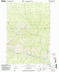
2004 Map of Acorn Butte
USGS Topo · Published 2007About this map
Payette National Forest and the Frank Church-River of No Return Wilderness dominate this high-altitude landscape in central Idaho. The map reveals a history of resource extraction and backcountry travel, centered around the Snowshoe Mine and nearby Snowshoe Gulch, where a Prospect is also noted. The terrain is characterized by steep ridges and deep valleys, with the West Fork Basin and the prominent Lookout Mountain Ridge shaping the drainage patterns of Big Creek. Unusual alluvial features along the riverbanks carry distinctively culinary-themed names, including Hard Boil Bar, Over Easy Bar, and Soft Boil Bar, likely reflecting the vernacular of local packers and miners. These riverside bars, along with Mile Flat, highlight the few level areas in an otherwise vertical environment. Cultural markings are sparse but significant, including the Bismark Trail and Grave Spring, which suggest the historical routes used to traverse these remote mountains.
Find a feature on this map
36 named features on this map. Tap any name to fly to it.
Don’t see what you’re looking for? This feature index may not catch every label — zoom into the map to look around manually.
Map Details
Editions of this 2004 Acorn Butte Map
This is the sole edition of this map. No revisions or reprints were ever made.
Other maps of this area

1956 · Elk City
USGS Topo · 1:250,000

1960 · Elk City
USGS Topo · 1:250,000

1962 · Mormon Mtn
USGS Topo · 1:24,000

1962 · Vinegar Hill
USGS Topo · 1:24,000

1973 · Center Mtn
USGS Topo · 1:24,000

1973 · Acorn Butte
USGS Topo · 1:24,000

1973 · Bismark Mtn
USGS Topo · 1:24,000
1973 · Monument
USGS Topo · 1:24,000

1978 · Wapiti Creek
USGS Topo · 1:24,000
1978 · Lodgepole Creek
USGS Topo · 1:24,000